correction to my earlier statement regarding the fourth stack. I don’t know why that fourth stack is out of alignment with the other three. The electrostatic precipitator stack was a fifth stack cut off in that photo. It is noticably wider and slightly shorter than the other four.
Historicaerials.com offers aerial photographs of this area in 1955-1973-1986-2004. The turntable and roundhouse were still there in the 1955 image. They were completely gone in 1973, the area having been turned into a concrete apron used for parking and storage. By 1986 an office building of some sort had been built on the location. I also found a website that has “balloons eye” historical drawings of Texas cities. The one for San Antonio dated 1886 shows a roundhouse and turntable across from the I&GN depot. Interesting because I had no idea they every existed. There is no trace of it today and they dont show up on any recent maps.
[quote user=“leighant”]
But this little creek is like a smaller version of a similar s
I just got MJ4562’s response: (quote) “Layout Room #1 Door A best describes my space.”
Tried juggling these elements every which way, since they make an interest exercise in how room orientation affects layout planning. I have “Room #4” drawn and written up so I will go ahead and present it…
N Layout “Room #4”
If our 10 x 12 room has its entry doors next to any corner, that orientation is covered in the drawings labeled Room #1 and Room #2. If the door is closer to the middle of the long 12 foot wall however, that allows a turnback lobe on each side of that long wall and room for a long tangent on the opposite 12 foot wall, which seems an ideal place for the downtown depot area with its small freight yard. (NOT a freight yard for classifying full-length through trains but a downtown yard for sorting local cars for pickup and delivery in the nearby area. Through trains are supposedly yarded in the SoSan Yard represented by staging at the south end of the layout, around the corner from Stockyards. Transfer runs may carry cuts of local cars between Sosan and the downtown yard. They would actually be made up BETWEEN operating sessions and stowed in staging.)
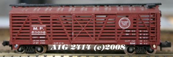
The closest model I can find to a Missouri Pacific stockcar suitable for in the 1950s is a “moldy oldie,” one from the early days of N scale.
Atlas stockcar catalogue #2414, MP #53098
shown in Irwin’s Journal “Atlas 1st Generation“ as marketed in late 1960s:
The car has molded-on ladder and grabirons. It is not as “fine” as much of today’s N scale. However, it is closer to the prototype than anything being made today, as far as I can find.
Back into the 1940s, bulk cement was usually transported in 2-bay covered hopper cars.
A photo of Missouri Pacific #2032 is shown in Train Shed Cyclopedia#75 p.347, which is a facsimile reprint for modelers of pages from the 1943 Simmons-Boardman Car Builders Cyclopedia which was published as a technical and buying guide for mechanical departments of real railroads.That photo describes MP 2032 as a 2 bay 70 ton covered hopper, 1892 cuft.capy built in 1941 by Mt.Vernon Car Co. The illustration shows a light gray car with black plain font (Gothic?) reporting marks on the second panel from the left end of the car and the Missouri Pacific buzzsaw herald on the second panel from the right end. I do not have permission to copy that illustration, but I can tell you the visual physical features of the car were identical to this 2-bay covered hopper I photographed at Glen Flora,
Cars for a MoPac Freight Station Some distinctive cars would appear at Missouri Pacific freight stations in the 1950s, such as the one just south of the passenger depot in . MoPac ran an LCL (less than car-load) business using a fleet of special boxcars. All these cars were restricted to Missouri Pacific and affiliated lines. I consider this a car a 1950s MoPac modeler NEEDS to have. I have one I bought 25 years ago because it was a distinctive design I remembered seeing in a book. Now I know it does not belong on my railroad and I need either to pass it on to someone else, repaint it or keep it of-layout as a display-only collector’s item. Interestingly, the cars were a mix of new and old. The new- they were brightly decorated in blue and gray, the sides blue on the top and bottom with a wide gray stripe running horizontal down the middle third of the cars’ height, and large script lettering “Eagle” with a smaller “Merchandise Service.” Doors were bright yellow and white, gray ends and roof.
Wow… that’s exactly what I needed for my question about Milwaukee then vs. now. Very interesting thread–I should have read this one before posting my Milwaukee question.
That website is a great resource for modelers. I have also found USGS topographic maps and Army Corps of Engineers aerial survey maps to be very helpful. I initially discounted them but later found they include considerable detail on ROWs and industry spurs as various points in time.
Many thanks to all that have posted. I am working on my own N scale track plan using leighant’s plans as a starting point. I’m also continuing to accumulate protoype information on south and central Texas railroads.
Since a big Swift processing plant was located adjacent to the stockyards, a layout of the scene in the 1950s could use a few Swift reefers. The most commonly seen Swift reefers in the 1950s would be wood-sided cars, 36 to 38 feet long, with hinged doors, steel underframe- either straight or occasionally fishbelly. There would even be an occasionally wood underframe car with truss rods. These would contrast, say, the typical Santa Fe refrigerator cars of the middle 1950s, when all the cars under 40 feet were gone from revenue service and all the wood bodied cars had been rebuilt as all-steel.
Ok… while somewhat on the same subject, but a different location, anyone have any idea where I could get a mid/late 1980’s and a 1990’s era city maps of Syracuse NY?
I haven’t been in Syracuse since 1971. Is there a big downtown public library with a local history room? Or does the University have a regional history archive or research collection? That’s where I would start.
I don’t know if they’d be detailed enough for what you want, but the US Geological Survey Store website at http://store.usgs.gov/ has older topo maps available for free download. Click on “Map Locator” and search for Syracuse NY and it’ll show you whatever selection they have available.
The library is one place I never thought of. Probably because it is downtown and parking is a bear and expensive too… But that doesn’t mean I won’t check it out.
There would not have been reefers with wood underframes in use in the 1950s. In 1935 cars with all wood underframes were efectively prohibited in interchange in that no railroad was required to accept such cars. Also, the billboard ban came into effect in 1938, not 1935.
Back in the 1940’s a lot of cement would have been shipped in boxcars too. I would not be suprised if the covered hoppers went to the cement business in kansas City since that would have been the growth area for the MP, the Gulf Coast hadn’t started booming yet.
Mexico was recieving grain in boxcars up until the early 1980’s (the elevators and mills in Mexico weren’t set up to unload covered hoppers). One of the first derailments i were to was a carload of corn for Mexico in a nasty “Route of the Eagles” boxcar south of Durand, KS in Dec. 1980. There were also 40 ft Route of the Eagles boxcars in sugar service hauling bulk sugar from Galveston to Sugarland, TX up until the mid 1980’s.
The MP also rebuilt some steel reefers into boxcars, there was an article on them in MR decades ago.
Wayne Cline wrote a book “The Texas Railroad” subtitled “The Scandalous and Violent History of the International Great Northern Railroad, 1866-1925”. I haven’t read all of it but the IGN was heavily involved in financial shenanigans.
While I’m sure Swift reefers were around, the majority of the reefers you would have seen in San Antonio were ART cars carrying produce out of the Rio Grande Valley and from the Sausage. Cyrstal City was HUGE produce center.
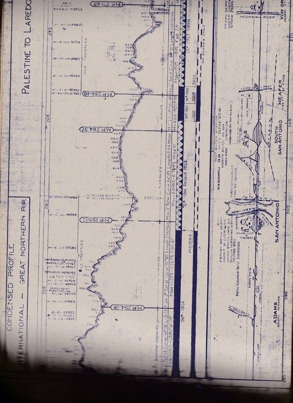
Note 90# rail and I will have to look at the key to see what type of ballast they used. Note two main tracks San Antonio to SoSan.
Yard limits are marked on the map. Bridges/overpasses are on the top/left side. The engine facilities at San Antonio had an oil column (note icon next to the water tank icon.)
The siding was Adams, the spur was Cementville, but the depot was at Monte Vista and was listed as a “suburban depot”. San Antonio had a agent, operator and dispatcher, plus a section quarters.
Trains to Corpus Christi would come through San Antonio and turn the corner onto the Sausage (and return).