The confusion is the Highway 95 is not completed in New Jersey and is not signed as indicated on this map. According to Wikipedia the Highway is scheduled to be completed in 2018 . Imterstate 95 in Pennsylvania will be rerouted to meet the alignment shown on this map.
I travel this area fairly frequently and this is true. In addition this area has a speed limit of 80 mph and most traffic is at 85-90 mph. The traffic is sparse enough that this is no problem.,
There was at one time a grade crossing on I 20 in Louisiana. I can’t remember exactly where it was but when I encountered it in the mid '80s I was amazed to come upon signals with barricades on an interstate highway. I had occasion to go that way a year ago and there were sign of it’s existence still there.
Although not a Interstate California 99 had a grade crossing of a freeway. This was located in Stockton CA on the Southern Pacific Oakdale branch. Originally a standard state highway that was upgraded to a freeway. Never saw a train cross but have heard it was a daily operation up until the proposed SP ATSF merger. Most of the Oakdale branch was abandoned in favor of trackage rights over ATSF. The branch was removed but as we know the merger failed.
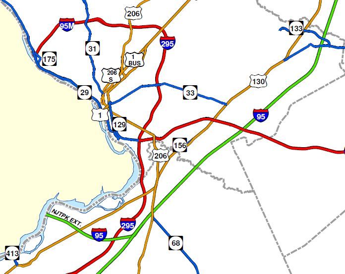
If you turn to your map you will see a green north-south road which is designated as I-95. Just below the blue shield is an east-west red road with no number on the map. That is I-195. If you follow it going west it comes to I-295 and ends (actually continues as state route 129). Turning north on I 295 and following it around west it crosses state route 31, and exit is used for about 12 years when I lived there. And a short way beyond the blue shield shows [I-] 95M. If you actually drive the road you will see a blue shield say saying I-95 but there is no indication of the “M” and I don’t know what the “M” means as you never see it on the actual highway. You are in Ewing, New Jersey a short way from the Pennsylvania border. And, once again, you are on I-95.
Michigan had another RR x’ing on limited access US 23 near Petersburg, South of Ann Arbor. It was a PC branchline to Ida. It was pulled out about 1980. Michigan also had a drawbridge on I-75 across the Saginaw River at Zilwaukee. After one too many freighters caused the bridge to be raised on a holiday weekend, they decided to build a high level bridge. A construction mishap caused a pier to settle, and “The Bridge that made Zilwaukee famous” took some extra years to build. It was completed in the 80’s.
I-43 is, indeed, east of US Hwy 41. And I-39 is west of it. The state of Wisconsin has been upgrading US 41 to Interstate standards for some years now. The Interstate highway route number designation will have to be an odd number, since it is a north-south highway. The numbers to choose from would be higher than 39 (since Interstate highways are numbered west to east) and lower than 43…which just leaves the designation Interstate 41 for the Milwaukee-Green Bay segment of US 41 (which will continue north to Hancock, Michigan and south to Miami, Florida). Afraid of the confusion that this might cause, the leading idea is to designate the route to be an extension of I-55 from Saint Louis to Chicago (and thence to Milwaukee and Green Bay).
I’d leave the designation I-41. With the common confusion of Interstate and US highways, especially when both are already freeways (or, “four lanes”), I really don’t see a problem occuring.
This is what I think is happening based on the informantion I have found on the Net and 30 years experience with the Calif Dept of Transportation (CALTRANS) most of which was in various jobs where I needed to use and understand the route number and signing designations and the records.
.I 95 has not been completed through the area… Currently traffic is routed through on highways with other designations. When it is completed I 95 will be one continous Highway with no breaks and no parallel sections.
The proposed route of I 95 has been revised at at some point in time . It appears the old route was to cross the Delaware River west of Ewing Township connecting to New Jersey I 95M ( see the map from the State web site that I posted earlier) which is currently signed I 95. The “final” route will cross the Delaware River south of Levittown. The I 95M designation would have been created for Highway Dept record purposes at the time the revised I95 route was adopted. The Highway signing was not changed on I 95M but will be changed ( perhaps to I 295) when the adopted I 95 route is completed. There will also be route signing changes in Pennsylvania
Nice picture. You will find similar signage a little bit east of Wytheville (If you wonder how to pronouce it, remember that George Wythe pronounced his last name “with.”), Virginia, where I77 and I81 run together. As you go south on I81, you also go north on I77, and as you go south on I77, you also go north on I81. I have been there, and my daughter noticed it last month when she drove from Bristol, Va., to Charlotte, N.C., and back. US11 and US21 used to be the same for a short distance through Wytheville. And, for three miles west of Bean Station, Tenn., you will find the same situation with US25E and US11W running together.
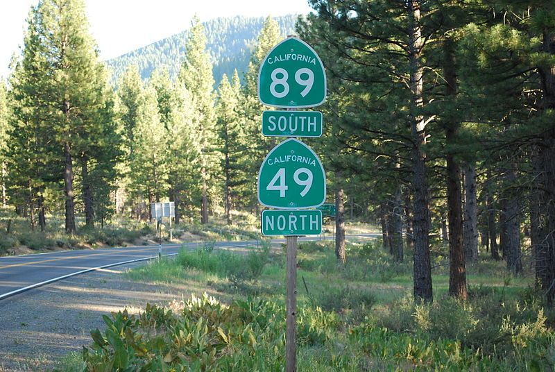
If you want to see the signs in the picture, drive north of Sierraville.
Connecticut wanted to improve Route 8 to interstate standards.
Massachusetts wanted to improve Route 7 to interstate standards.
Connecticut thumbed their nose at Massachusetts and Washington, and improved Route 8 with their own money. It is simply “Route 8” and ends at Winsted CT, just a few miles short of the MA border.
Winsted used to have passenger service on the NH railroad to NYC.
I personally recall seeing that railroad line crossing I-94 at grade in Michigan a number of times, though I never saw a train on it. As I recall, it was a light traffic branch line, or possibly part of a siding serving an industry. I imagine that those who installed it knew that the rail line had a short life expectantcy, and that it was not worth building a grade separated right of way under those circumstances. I. E. Quastler
I recall I-94 in Michigan having several grade crossings at one time, into the 1960’s. There was one off the C&O ex-Pere Marquette between Sawyer and Bridgman MI serving a sand-mining operation on the north edge of Warren Dunes State Park. There were two others at Kalamazoo, one serving a military base bordering 1-94 on the north side. There were signals as shown in the photo, plus overhead traffic signals as on highways, but no gates. I never saw trains use these crossings. I wasn’t aware of I-94 being a gradual upgrade so that’s interesting history.
There has been an instance of a crossing at grade on an interstate. Interstate 35 in Austin, Texas crossed the TNO (SP) tracks in north Austin. This was in place for several years before an overpass was constructed.
There was a “dodge” of sorts in this area regarding the naming and numbering. The local name was “Inter-regional Highway” partly because of the Austin crossing (originally Austin & Northwestern) and two in Temple (Santa Fe). It was numbered US 81, and I seem to recall the signs changing once the overpasses were built.
I can’t offer any actual Interstate crossings of my knowledge. I do remember a report released in 1970 comparing the then-new Interstate 80 to its former non-limited-access highways for a transcontinental crossing, and it showed that instead of hundreds of railroad crossings, I-80 had one. I never found out where that alleged crossing was; I suspect it may have been a crossing on an exit ramp or the like.
In NON-Interstate limited-access highways, I can offer the crossing of US 322 by the Middletown & Hummelstown on the south side of Hummelstown, Pa. US 322 was upgraded top near-Interstate standards in the area in the 1970s, as I recall. The crossing was marked “EXEMPT” almost as soon as it was installed, and even the tourist-and-freight “Milk & Honey” seldom uses it.
Into the 1970’s there was an at grade railroad crossing of the ramps on the north side of the I-80 freeway at Abernathy Rd west of Fairfield, CA. The track, but not the ramps, is shown on the 1967 USGS map. The 1980 map shows the ramps, but no track. Later when the Hwy 12 interchange was built, Anernathy Rd lost its direct conection to the freeway.
I personally saw the track crossing the ramps in the mid 1970’s. I think the track was not in service at the time I saw it. I lived in Fairfield 1973-1980.
Thanks DSchmitt for looking up the plans to connect the two I-95s in NJ/Penn…originally there was to be a ‘missing link’ of I-95, built between the north side of the Trenton beltway northeastward to I-287 in New Brunswick (parallel to US 1). In fact, there still is the proverbial “wide spot in the road” on the Trenton Beltway where the I-95 North interchange was to be built. So up until recently, I-95 officially ended at the top of the Trenton beltway and officially began again on the NJ Tpk at the I-287 interchange (regardless of what some maps say) and ran from there along the NJ Tpk to the GW Bridge, so there weren’t two I-95s, rather it was one, with a gap in the middle.
My favorite at grade rail crossing was on what is now I-395, inside the Washington DC beltway, near Alexandria, where the Washington & Old Dominion RR crossed on its way to Potomac Yard. I-395 was originally built as a freeway, but it was only two lanes in each direction and it was originally VA Rte. 350. In those much-lower-traffic-days, it was nonetheless a freeway, subject to rush hour, and occasionally freights would cross at rush hour, screwing the whole thing up royally. Sadly, the W&OD bit the dust in the late 60s, the grade crossing was removed, and shortly thereafter the freeway was upgraded to its current vast size, and no trace of the crossing remains.