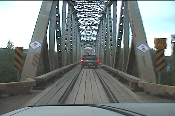
I don’t think I’d want to be on this bridge, espeically around the time when a train is going to come through. This bridge on the Fort Nelson River in British Columbia, Canada, has a single roadway that is used for road and rail traffic. The bridge’s narrow deck only allows for one way traffic. I wouldn’t think this type arrangement on a bridge would be used or allowed in this day and age. Maybe this bridge is in a remote area that gets little rail traffic? Up to the 1950s and 60s, some bridges shared their decks with rails used for streetcars and light rail, but I haven’t heard of any bridges using such a combination in modern times. Most bridges that permit both rail and road traffic typically have separate decks for both.
Across the waterway between Houghton and Hancock, Michigan (on the Keewenaw Peninsula, in da Yoo-Pee), is a double-deck lift bridge. The lower deck has a railroad track (probably now abandoned–Soo Line at one time, I’m sure) and a roadway; the upper deck has a roadway. The bridge can be lifted to the point where the lower deck becomes the upper deck roadway, or raised completely above both levels. I’m not wording this well, but I hope you can follow it). I’m sure that at one time drivers had to share the lower deck with the trains fairly regularly.
I have seen (and crossed, on foot and by rail) a similarly configured truss bridge across the Kiso River at Agematsu, in central Honshu.
The railroad was there first. Old photos show the bridge with a typical open deck - ties and a few planks parallel to the rails. By the time I first encountered it the floor was planked full width to railhead height.
Since the mid-'70’s, when the 2’6" gauge Kiso Forestry Railway suspended operations, road traffic has been the only user - assuming that the old bridge hasn’t been replaced by something more modern (and wider.)
Here’s a satellite image. The bridge is the only one for miles around, and very near the end of the line. Looks to serve a large lumber yard. This is near the northeastern terminus for the old BC railway.
I have been across that Keewenaw bridge a million times, but never thought much about its functionality. When the bridge was fully down, the railroad deck was on the bottom and the road deck was above. It could be raised for some clearance without blocking the road traffic by lifting the railroad deck up to the level of the road. This would block railroad passage, but that was infrequent compared to the demand of road traffic, which could continue by using the railroad deck. For maximum clearance, the two decks were raised way up, thus blocking the passage of both trains and road traffic.
I am not sure if there was ever a second roadway that could use the railroad deck when the decks were fully lowered. Certainly the deck that carried the railroad could accommodate road traffic since it was indentical to the upper deck except for the addition of rails.
This raises a question: Since the railroad is gone from the area and traffic is reaching capacity at times between Houghton and Hancock (the towns on either side of the bridge), I wonder if planners are considering adding a second road to connect with the lower deck, and making each deck a one-way thoroughfare.
The old Minneapolis Northfield & Southern railroad swing bridge over the Minnesota River at Savage, MN was shared with the road. I don’t quite recall the t
The busiest highway/rail bridge that I knew of was the one across the Mississippi River at Vicksburg that carried both US 80 and the IC’s Shreveport-Jackson-Meridian line. It was built in 1930 as a toll bridge and its two highway lanes were more than adequate for traffic of the 30’s and 40’s. US 80 was a major E-W truck route and as highway traffic grew the bridge became increasingly more hazardous due to it’s narrow, 9’ wide IIRC, traffic lanes. Going east across the bridge with a train on it was not for the faint of heart - semi’s whizzing by only 18 inches away on your left with a train no more than 2 feet away on your right. Bad enough in the best of weather but imagine what it was like at night during a driving thunderstorm.
About 1966 a parallel I-20 bridge was completed and US 80 traffic was diverted to it at that time. The old bridge remained open to local traffic for a while longer before being permanently closed to vehicular traffic. Today it is used only by the railroad which now is the KCS Meridian Speedway.
Both the Williamsburg and Manhatten Bridges in New York City cary both road and subway traffic. The Brooklyn Bridge used to carry both but I believe subways were diverted at some point.
Several bridges in Chicago carry both local streets and the EL.
One of the more famous long shared rigth-of-way rail/auto bridges was on the PRR crossing the Susquehanna between Wrightsville and Columbia, PA. It had significant rail traffic, including passenger trains. The bridge was closed to autos when the trains were using it but cars going the same direction as the train were often sent across just ahead of the following train. It was a toll bridge and made money for the PRR until PA built a highway bridge near it.
The one I was the most impressed with was the 2 level bridge crossing from Niagra Falls, NY to Niagra Falls, ON at the Whirlpool area north of the Falls. I remember crossing underneath a train and looking up and seeing the cars moving directly above you over the decking and ties–it was rather scary. Its no longer used by trains but it hasn’t been that many years. I seem to remember that I heard the main reason for its not being in use anymore was due to the desire of the Ontario city to get the CP tracks out of the tourist area but can’t say that for sure.
The Williamsburg, Manhattan and Brooklyn Bridges had the rail traffic well segregated from road and pedestrian traffic. OTOH, the swing bridge that carried Broadway over the Harlem River once had rail traffic on two levels (rapid transit on top, streetcars below) and the streetcar tracks shared the pavement with rubber-tired vehicles.
The lower deck of the San Francisco Bay Bridge had two rapid transit tracks plus vehicular lanes. The rails were later removed.
That’s interesting. I have never been under that bridge to see how things come together. I suppose that since the railroad is gone, you can drive on the railroad grade. I always thought that was a pretty clever arrangement of one-way roads that circulated through Houghton and Hancock, and across the bridge.
There is still such a bridge in daily use on the single-track secondary main line between Kiel and Flensburg in Northern Germany traveled by hourly ( in each direction ) passenger trains, mostly diesel railcars. Road traffic is one-way regulated by traffic lights. When trains approach, crossing gates are lowered to bring road traffic to a standstill. I’ve used this bridge quite often.
“The Frisco Bridge was built by the Kansas City and Memphis Railway and Bridge Company, a company that was formed by the Kansas City, Fort Scott, and Memphis Railroad specifically to build a bridge over the Mississippi River. In 1901, KC, FS, and M was bought by the St. Louis and San Francisco Railroad, which was commonly called the Frisco. The Frisco system was bought by Burlington Northern in 1980, which is now part of BNSF.”
The above quote is from the link presented above… The bridge as originally built was a railroad bridge and also incorporated a wooden deck to allow two way traffic across the first crossing of the Mississippi River south of St. Louis when it was constructed in 1892. The abutment at the East end of the bridge incorporated a Strong Room in its base for the funds to be handled and stored as it was a toll bridge for wagon and foot traffic for a number of years- one of the photos on the abve link shows the north corner of the East abutment.
One of the other posters mentioned the US-90 bridge on the north end of the Baton Rouge,La area. It is also a railroad bridge with traffic lanes along the north and south sides. Truly, a memorable crossing when it is also occuppied by moving rail traffic.
At New Orleans, the Huey P. Long Bridge, a high bridge crossing over the Mississippi River is almost as thrilling as a carnival ride as trains cross with locomotives in run eight hammer up the steep grade and then power down the other side in dyamics; while motor traffic is jammed up on its roadways in rush hour.
That would be the Alaska Railroad tunnel between Portage and Whittier. The tunnel is the only land access between Anchorage and Whittier. It used to be a rail-only tunnel, and they ran shuttle trains with flatcars for autos and trucks. A few years ago they put down road surface over the tracks (tracks still useable) and large queueing areas with traffic lights at either end for cars to wait for the one-way tunnel to clear.