I heard that the two railways are sharing track in British Columbia’s Fraser Canyon. Trains head one way on the Canadian National trackage and trains head the other way on Canadian Pacific’s trackage. If this is the case, where do they cross over to their main lines. Is there other places they share trackage?
I think CP & CN both have trackage in the Fraser Canyon and they alternate sides via trestles in a place or two, I’m sure they do not share one actual track, even further North they cross over the river to opposite sides, can anyone attest to this??
Basically, that’s the way it works. There is no way (if you’ve ever seen the canyon, you’d see why!) either one could have a double track, nor that they could be on the same side of the river in most places. So they came to a most sensible agreement to operate the canyon as a double track main, CN trackage used one way and CP the other. There are junctions at both ends of the setup, so they can get back on home rail.
Commensualism: “I’ll do it for you if you do it back to me.”
CN and CP use directional running from Basque, near Ashcroft to Matsqui / Mission, BC, about 160 miles. They go west on the CN and east on the CP. At Basque both lines are on the same side of the Thompson River, right beside each other. At Matsqui on the CN they use a CP bridge to cross the Fraser River to CP’s Cascade sub at Mission. This is basically what they do but they have added a bunch of other agreements to Vancouver and Roberts Bank and you could find either railroad on each others line in a lot of places out there.
Barry, Regina
I am not positive, but I believe this is a crossing point for each railroad, near Boston Bar, in the Fraser River Valley.
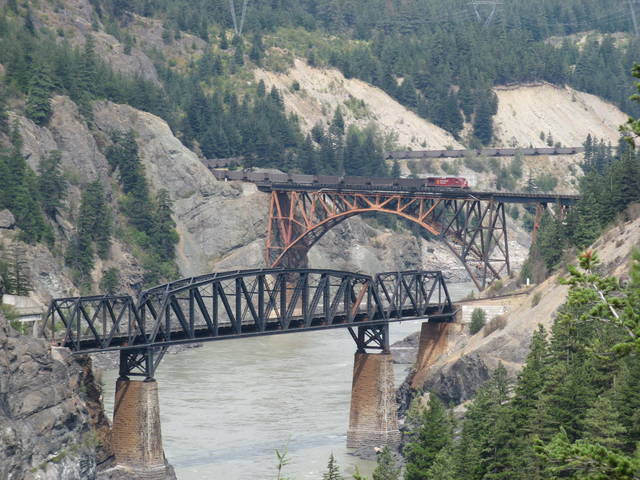
This is actually all CP rail that is visible, at a place called Cisco. I have travelled the Trans-Canada highway many times through the canyon, and have always found it amusing that one can see either corporation’s trains on both sides of the canyon seemingly willy-nilly, but it must be that there is a direction consistently when sharing one side or the other.
Just checked Atlas of Canada site: In the canyon the CPR and CNR DO NOT share track, each railway has it’s own ROW , in the lower Fraser the CPR is on the west side of the canyon and the CNR is on the east side, in the upper canyon a trestle crosses over the river south of Spences Bridge, now the CPR is on the east side and the CNR is on the west side then both tracks head east and the CNR goes north to Jasper. Two seperate rail systems. NOW there is some agreement in the Fraser Valley( near Vancouver) where the CPR or CNR share trackage to haul coal to Roberts Bank, but this is NOT in the canyon.
Yes they both have lines in the Thompson and Fraser valleys, but both railroads run on each others line, westbound onthe CN and eastbound on the CP. This works much better for them than running both directions on their own track, it becomes a double track line for 160 miles.
Barry, Regina
Selector actually has a picture of it above. The orange arched bridge is the CN line and that is a CP coal train on it heading west (timetable direection) to Vancouver Roberts Bank. The CP line is the other bridge below.
Barry, Regina
The Atlas should be updated. The shared track agreement through the Fraser Valley and the Fraser Canyon (beyond Hope) has been in use for several years.
Does anyone know where to find dimensioned drawings of these bridges? I want to model one or both of them as accurately as possible from scratch. Thanks in advance for any possible help.
Thanks,
Trainhawk2468