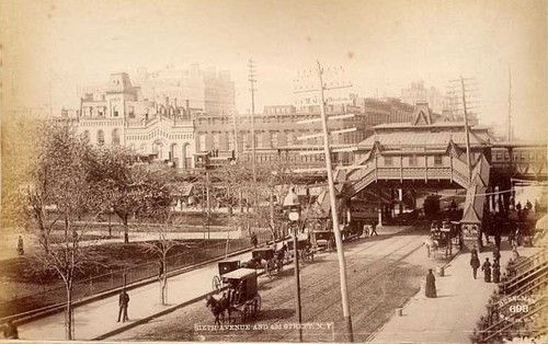
Looking at the cars, my guess would be more like 1938. Was the 42nd Street overpass that took Park Avenue around GCT not built yet?
The overpass was built in 1936-1937 as part of the conversion of the old New York and Harlem RR tunnel from streetcars to “The Park Avenue Vehicular Tunnel,” I believe the whole business a Robert Moses project. The overpass is not in the photograph. (Tunnel clearances were (are) restricted deliberately to exclude buses and trucks.)
The 1908 date was on the photograph.
The cars in that photo look more like my Dad’s 1928 Buick, not his 1938 Dodge.
If the photo date ends in “8” it would likely be 1928, (not ‘1908’ of course). Note the bus.
If that is the 6th Avenue El, why are there cars on it, why is it a long arch, and why is it right where GCT would be? Even in 1938 the Sixth Avenue station remained something of a baroque horror

And it stayed baroque until its demise in 1939…

The “Swiss Chalet” style of station architecture that prevailed throughout the Manattan Elevated was not by any means original, but was the result of careful upgrading by the IRT just before WWI, the same upgrading that provided a continuous center express track and the hump express stations on all but the 6th Avenue north-south lines. The wider avenues, 9th, 3rd, and 2nd, had original double-track lines with a space between the tracks that permitted the installation of the continiuous center track. The two tracks on 6th Avenue were always adjacent. Indeed, there were centersidings at points on the other three avenues as some locations, even in the steam days.
The lack of a Swiss Chalet station at the 6th Avenue elevated in the background dates the photograph at least several years before WWI. but after the short 3rd Avenue to Park Avenue one-block shuttle had been removed.
The original Manhattan Elevated stations were quite primitive in comparison.
At the time of the photo., west on 42nd Street from 3rd Avernue, the 6th Avenue and 42nd Street station probably resembled this. the 9th Avernue and 42nd Street station at the time of the construction of the 2nd track.

Look carefully at the picture again.
6th Avenue and 42nd St in 1879:
That is not measurably different from the pictures I provided of that station in 1938, and as being dismantled, so it was never reduced during that interval to some smaller configuration. And it was never removed with a long arch being substituted.
Here is a picture of the 6th Avenue station in 1926, two years before the putative date I assigned to your original view.
Note the very distinctive buildings in the background of these pictures. Note that in the image from “1908” these are measurably further down than the visible bridge… just farther down that we understand the 6th Avenue ‘chalet’ is behind the visible arch with the cars on it. If I enlarge the picture to its resolution limit and look carefully, I think I can see some details of the underpinnings of the 6th Avenue station a little further down 42nd… just enough that the visible buildings would be in the correct perspective.
The installation of a free-span arch completely across 42nd St. and its sidewalks was part of the original road ‘around’ GCT which involved construction of the New York Central building (later the New York General building via some constructive stonecutting in the word ‘Central’ on the facade, and later still the Helmsley Building) which was dated 1928. Whet
The RR and streetcar tunnel’s mouth was north of 40th Street, witih tracks reaching street level between there and 42nd Street. The Vehicular tunnel’s mouth is just north of 39th Street, with the road reaching street level just south of 40th Street. The ramp to the GCT roadways starts on the north side of 40th Street. So, you are correct, the GCT ramp and overpass did exist during streetcar tunnel days, with the streetcar ramp essenrtially under the GCT roadway ramp.
The early Baroque 6th Avenue and 42nd Street Station does not seem to my eyes to be the same station as the 1938 station. Too many detail differences, in windows and roof construction. I may be wrong. An explanation is that the photo I posted was at the very time of the IRT improvements, and the old Swiss Chalet had been torn down for the replacement. But the view, if west, must be from Park Avenue, not Third.
However, if you have a better explanation, I’ll gladly learn
The early photo you posted seems to indicate where the IRT Station architects got their “Swiss Chalet” inspiration!
To me, the mass of the structure, the underframing, the roof height, and the stairs down to the sidewalk on either side, on the side of the station we would have seen from the picture you posted, are all common from 1879 all the way until we see the stairs being disassembled.
ISTR that architectural changes were made over the years on some of the El stations. I see different window detail in the 1926 view, but the openings and spacing appear to be very similar. Perhaps there is documentation on ‘style modernization’ of some of these stations over the years, either to reduce maintenance or make them more ‘modern’.
But very clearly the bridge pictured in your photo is NOT the 6th Avenue El, it’s a block or more further east. And is exactly where a bridge at the end of the ramp up to ‘mezzanine level’ of GCT would be, and looks exactly like the design of bridge used there.
The view is from an elevated location, at a ‘parking spot’ for crosstown cars (see the painted line, and the bystander idly standing in the street?) and I can think of little better a location that would afford such a view than the Third Avenue El structure. The arch bridge in the distance is exactly where Park Avenue would be, another reason why the view couldn’t be taken from there. And yes, if the view were from Park Avenue you would see the distinctive shape of the 6th Avenue El station (as it existed from 1936 to 1938) squatting in
You are absolutely correct. I just pulled up the picture on a large screen, and yes, I recognize the arch bridge as the Grand Central roadway bridge, not anything resembling an elevated railroad.
My apologies to you and the other readers.
The view is f rom 3rd Avenue, the first intersection is Lexington, and the bridge in the picture, and the details are there, is the Park Avenue roadway overpass.
Furthermore, when I use the Zoom enlarge feature of MSPaint, I can clearly see a 4thb and Madison NY & Harlem streetcar under the roadway viaduct, either just emerged from the tunnel and about to turn left on 42nd for the short trip west to Madison or doing the reverse.
Hats of to you!
Regarding the date, note that the only bus in the picture is a hood-in-front,
But I agree 1908 seems too early for the automobiles. 1928 does seem reasonable. The streetcars would fit also, since no single-truck seem to seen.
I noticed a movie marquee on the left side that had Joan Crawford “Laughing Sinners”, that was released in 1931.
In December 1935, the 4th and Madison line went bus, the first of the major “Green Lines” bus conversions. By 1935, were not some autos showing signs of "streamlining?’
Look at the pictures I linked that were from 1938 or later and look at the cars on the street. Visibly more ‘streamlined’ compared even to cars of 1932.
Given that a 42nd Street Movie Theater probably was a 1st-run theater, we should probably date the photo at 1931.
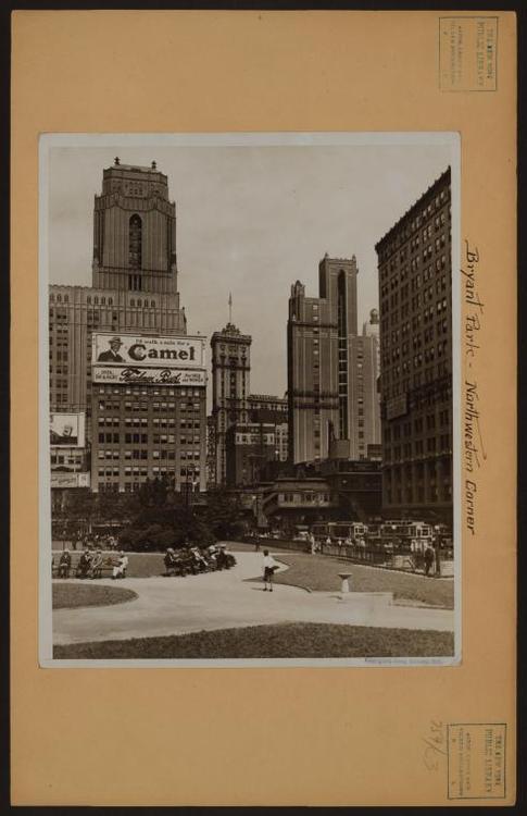
And in thanks for the three excellent views:


Ovwemod was probably correct that the bypass roadways, the arch roadway bridges over 42nd and 41st Street, and the ramp to street level at 40th Street were all part of the Grand Central Terminal overall design. But completion of the roadways, bridges, and ramp waited until 1924. The one-block elevated railway branch was in the way and was not closed until 1923.
Here is a 1921 photograph. also from Henry Raudenbush. The streetcar ramp to the then-streetcar tunnel is to the right of the photo, starting south of 41st Street, with its portal, to be under the future ramp, just north of 40th Street.
For the 1936 conversion to the Robert Moses “Park Avenue Vehicular Tunnel,” the Tunnel’s portal and ramp were each moved one block south. The ramp from the GCT roadways thus has a direct same-lanes connection.

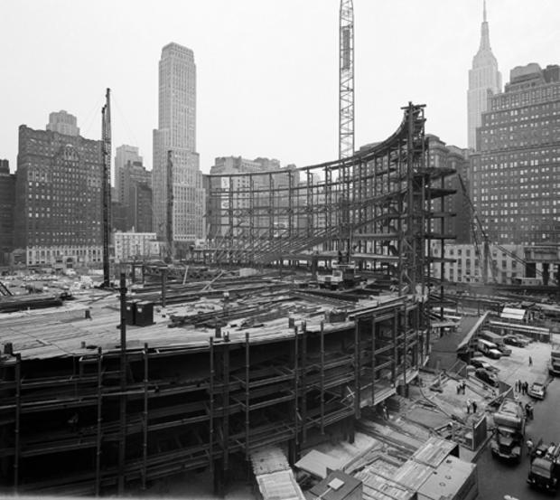
That is a perfect ‘missing link’ picture. Does he have more that show the progress of the work?
Something possibly relevant to this is the way this road improvement was to be preserved in the ground plan of the proposed Hyperboloid project of 1954, kind of an Incinerated House version of GCT at the base of the twister. You need to know what you’re looking at to appreciate what Pei was doing – there’s all sorts of proportional retention in the very vestigial arrangements, infinitely more successful than the same general idea tried at the General Motors building.
Were it not for the specific site, this would be one of the greatest ‘unbuilt regrets’ of any Manhattan project; would that something of that distinction had been part of the Penn Station Replacement once that became inevitable.

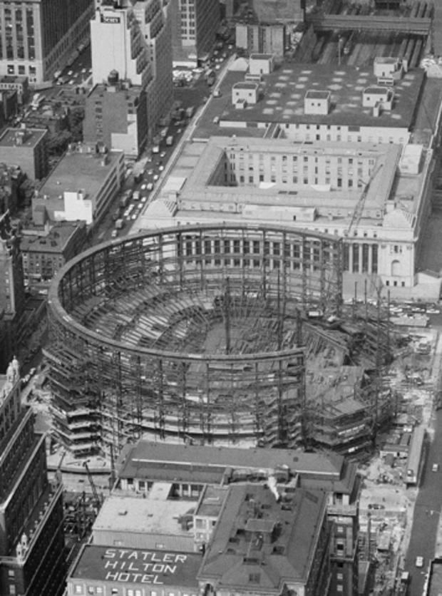
Vs. this
.
Got to a computer, and put it in the correct prior-post context.
Not fair. Not like U-tube, wehere you can just look, enjoy, and leave.
They ask too many questions in my opinion.
Sorry, I thought it would just render the picture of MSG going up. See the edited post for the pictures in context.