Last weekend I drove between Lewisburg, PA and State College, PA on Route 45 mostly paralleling a former PRR branch line through Mifflinburg and many smaller towns. But I cannot find pictures, history, nor operations concerning the line. Edwin Alexander’s and Don Ball’s PRR pictorials do not reveal anything. Anbody got ideas of books or sites to search?
By the way, anyone interested in Colonial and Federal style architecture has to see Lewisburg and Mifflinburg fir superb conservation, restoration, and presentation. Home of Bucknell University, too.
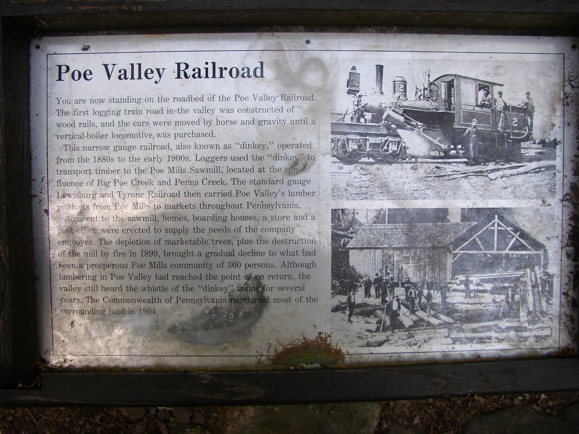
I am not familiar with the line, but here is one photo. And here, here, here, and here. One caption said “Lycoming Valley train KH37 makes a rare trip onto the Ex. PRR Bellefonte Branch to pick up 4 loads of scrap rail. Unitrac is pulling up the line from Mifflinburg to Lewisburg and in a few more weeks this shot will not be possible…”
Lewisburg is also home to a U.S. Penitentiary. Red brick, scary Gothic architecture, ornate smokestack. Like a monastery with a 40-foot wall and gun towers. Made the drive on U.S. 15 up the Susquehanna from Harrisburg a number of times.
I was laid-over at the Truck Stop on top of Snow Shoe / Someone mentioned that there would be some’ old trains running on the rail line at the East side of Snow Shoe. (about 9 miles) Back then the Exits were numerically numbered from West to East SS was Exit 22 and the Milesburg/ Bellefonte was, I think,23)
There was little information on what was going to happen and when, so I eased down to the Bald Eagle Truck Plaza at E-23 ) Found out there, the Train was coming out of Altoona and would be powered by PRR #1361 ( A K-4 Pacific) . I took some poor pictures with an old Kodak, I kept in the truck. It was well worth the side trip.
That line came off the PRR’s Harrisburg-Northumberland-Buffalo line on the easterly side of the West Branch of the Susquehanna River at Montandon, at about these Lat. / Long. cords.: N 40 58.027’ W 76 51.478’
It then crossed the West Branch on a long multi-span through truss bridge just north of the Rt. 45 bridge, at about these coords.: N 40 58.077’ W 76 52.743’
In 1987 or ‘88, I designed and staked-out a connecting track in Lewisburg between this line and the former Reading RR Williamsport line, at about these coords.: N 40 57.858’ W 76 53.342’
By then the line had already been cut back to about Mifflinburg.
Thanks, Paul…you da man! The Susquehanna River bridge still stands but is shorn of track and looks dangerous at least to trespassers while its rust gives it an unstable look. The Right of Way from Lewisburg to Mifflinburg is a well kept Rail Trail while west of M’flnbrg it is just an abandoned right of way.
That bridge will still be there long after we’re all gone. In the mid-1980’s - during that highway/ bridge funding ‘crisis’ - another contractor friend and I looked at it for the purpose of reusing portions of it - the individual trusses - for local township/ county secondary roads and state game lands & forest roads across some of the larger streams. It had plenty of strength for that, but would have been only 1 lane wide - and some of the spans were too long for those applications, etc. Technically feasible but perhaps politically, environmentally, and financially challenged.
I expected the bridge to be part of the rail-trail, but I see that the adjoining ‘new’ PA Rt. 45 bridge has a decent walkway on its south side, so there’s not as compelling a need for that now. Also, since there’s not much R-O-W on the eastern side to the Montandon Jct. location to make into a rail-trail there (and I believe the former small RR bridge over PA Rt. 405 has since been removed).
As best as I can recall, the line west of Mifflinburg was abandoned well before the mid-1980’s, thus was not acquired by the local multi-county SEDA-COG Rail Authority, nor was it subject to the ICC/ STB’s “trail condition”, so highly unlikely it will ever become a rail-trail.
It’s pretty good, and appears to have good references, except that I disagree with the assertion that “It* has since become a rail trail.”, referring to the middle portion of the Bellefonte Branch from Mifflinburg to Coburn, abandoned in 1970. To the contrary, that’s still under study, and the fragmented ownership as a result of that early abandonment appears to be a major obstacle to reconstituting the line as an integrated trail. For more on that, see this presentation from 2013 (49 pages/ slides, approx. 4.0 MB electronic file size in this ‘PDF’ format), which also includes some photos and info on the history of the line:
Paul and Wanswheel! What a wealth of information from both of you!..and I suggest both of you click onto the links the other has provided for a different perspective of history of the railroad and the area than what you have presented. The tunnels are most interesting, the concept of which my PA Atlas and Gazetteer from DeLorme only faintly suggests nor revealed in the PA County Maps by Bureau of Maps of Hartjes Center WI. I can see that it was an agricultural line but felt there must be some mineral wealth back there someplace. I see why it could never be a mainline nor even a secondary back up to the main thus being sliced and diced to death. From what I saw…and I did not wander off Route 45…was the rail trail in place from Lewisburg to Mifflinburg but no other traces of activity west from there. I doubt I will get back there soon, but will wait until Fall when the trees lose their leaves and paths and views open up. Thank to both of you…
It diverged from the PRR’s Williamsport Division or Northern Region (Harrisburg - Buffalo) Main line at an interlocking plant (manned until 1958) in the village of Montandon, crossed the West Branch of the Susquehanna and the Reading’s “Willy and Philly” at another interlocking tower in Lewisburg ( designated “UR” and manned by the Reading, likely open only by train order when needed in its last years),
From there, the line paralelled PA Route 45 for another ten miles or so to Mifflinburg, then crossed the highway at grade and lost itself in Hairy John State Forest; highlight was a short, unlined tunnel through a small ridge of solid rock at Coburn. This was a favorite rock-climbing spot for Penn State students during my undergraduate years (c. 1970), but by then, service had been cut back to Mifflinburg.
The line eventually emerged from the woods at Spring Mills, turned northward at the village of Lemont (about three miles from State College Borough), served a Corning Glass plant opposite Nittany Mall and passed in front of Rockview Penitentiary before following Spring Creek to Bellefonte, where several substantial limestone quarries were based. The last few miles to a connection with the Bald eagle Branch at Milesburg were somewhat more heavily used, guarded by the Pennsy’s “Block-Limit” or “Unattended Block” Stations, and were the scene of a fatal accident reported in an ICC investigation sometme around 1950.
Oh yeah ! That URL isn’t near descriptive enough - Mike’s (Wanswheel’s) link is to the reference I wanted to see the most, the thorough history by Mike Bezilla (everything except the name of the foreman on the track gang, it appears . . . [swg]). It’s “The PRR’s Lewisburg & Tyrone Railroad” by Michael Bezilla, from The Keystone, the quarterly magazine of the Pennsylvania Railroad Technical and Historical Society, Spring 2006, Vol. 39, No.1, pgs. 18 - 40 plus masthead page (22 pages total, 6.91 MB electronic file size in this ‘PDF’ format):
This thread illustrates the great thing about this Forum - ask a question or comment on a topic, and a few people will generously contribute their time and knowledge. From this alone, I found out about the Buffalo Valley Rail-Trail (had no idea before this, even though it’s less than 100 miles away), plus all that history, and an explanation for some other things I’ve seen out towards Tyrone. Thanks, Mike (and Henry).
That trail and tunnel is hard to locate on a map, and to find directions to it/ them. Unpaved roads to get there. Here’s some info:
About 3 miles southeast of the village of Millheim, at the intersection of PA state routes 45 and 445. Can’t get to it from there, though - need to come off US Rt. 322 a little north of the town of Milroy, then go about 10 miles to the northeast, to and through the several ‘units’ of Poe Paddy State Park.
Poe Paddy State Park Campground - closest to it: N 40 50.073’ W 77 25.036’
“James Poe, son of Thomas, was born in what is now Antrim township, Franklin county, Penna. April 15th, 1748. He was brought up on his father’s farm as was most of the sons of pioneers, and found it necessary to earn his bread “by the sweat of his brow.” As early as the 26th of July, 1764, although but a lad of sixteen years, he formed one of a party of settlers who, under the command of Lieut. James Potter, persued the savages who had massacred the schoolmaster and scholars at Guitner’s School House. When the war for independence became an established fact, James Poe was among the first to offer his services to his country. He assisted in the organization of a company of associators in 1776, of which he was a lieutenant. He was commissioned July 31, 1777, captain of the Third company, 8th battalion, Cumberland county militia, commanded by Col. Abraham Smith. He held the same position in May, 1778, and from that on until the close of the revolutionary struggle he was in active service, especially on the frontiers…”
Pennsylvania Forests magazine article indirectly mentions Capt. James Poe, for whom Poe Creek (and everything else) was named. He was the son-in-law of Gen. James Potter.
Clicking on the link at the bottom I found the piece somewhat misleading but informative. It states that this segment of the Rail Trail is the only section upon which bikes can be ridden but the section east from there, between Mifflinburg and Lewisburg is open to bikes…but I do think that is a very recent event.
Fascinating line; one of my all-time favorites. I’ve followed it and 'splored it a few times. The area east of Coburn is particularly scenic. Until around the very early 1950’s, the line had mixed milk train service. Power was usually a G5s 4-6-0 train or one of the small, old 4-4-2’s in the last years. At the very end, a 2-8-0 was used. The train usually consisted of a handful of freight cars, a couple Sheffield Farms milk cars, a B60 baggage car, and an MPB54 mail/passenger/baggage combine. I think I have seen at least one photo showing the train with a larger combine and a full-sized P70 coach. Clarence Weaver took moving pictures of the train, and those have been available on tape in the past. Don’t know about current availability. The mixed originated at Sunbury and ran to Montandon, where it left the main and took to the branch. I think one milk car was dropped at Coburn and the other may have run all the way to Bellefonte, where the train was turned. Bellefonte had an incredibly tight wye. Upon return to Sunbury, the milk cars were forwarded to Philadelphia (or maybe the New York area) on other trains. Bellefonte was also served by a passenger train from the west. It was the regular Bald Eagle Valley passenger service which had to make a backup move to serve Bellefonte. That train’s K4s did not turn on the little Bellefonte wye, but I was amazed to see that 1361 actually did make it thru those curves on an excursion or two in the nineties. The Weaver films also show PRR H10s 7688 (the one that’s preserved in the museum at Strasburg) on the line. Operations on the line ca. WWI(?) were mentioned in the excellent book SET UP RUNNING by John W. Orr.