Locating rail up the Andes in the 19th century

Some of you have probably heard of the famous late-19th-century railway from Lima into the Andes. One obvious engineering problem was how to hold a grade under about 4%, with tolerable curvature, in terrain like that. This was standard-gauge, adhesion, going up to about 5000m altitude.

A proposal that was sidelined — perhaps not purely on technical grounds — was that of Gerrit Smith Backus, then a senior engineer in Peru and formerly chief engineer of the Sewanee Mining Co. Railroad. A map and profile for his preliminary proposal (1962) are here:

Contemporary evidence strongly suggests that the line in the profile means what it seems to mean: choose a guiding grade for long stretches of route, and if the valley floor is rising at 2.5% while your desired railway grade is 3.5%, climb the valley side at 3.5% and gain height relative to the river, so that later, when the valley rises at 6%, you can “spend” that height and stay within the ruling grade. In other words, not just local smoothing, but globally conceived location on a very large scale, with “preventative” or “proactive” hillside cuts over tens of kilometers.

(All the same, the line shouldn’t be read naively, or else it would imply bridges hundreds of meters high.)

My questions are:

  1. What precedents did this strategy have by the 1860s?
  2. Had anything like it been attempted at anything approaching that scale?
  3. Would engineers of the time have regarded such a proposal as intelligible and serious?
1 Like

The link to the Rumsey Collection ‘verifies’ forever, no matter what I do. Their new AI-assisted search does not recognize any Backus in Peru; perhaps it has been entered a different way.

It was not unusual for early railroad lines to use switchbacks to gain altitude, especially in mountainous regions (see the ‘Devil’s Nose’ in Ecuador) rather than have to resort to numerous bridges, spiral tunnels, Techchapi-like arrangements, etc. When steam railroads were the ‘only’ alternative, this might be cost-effective, but it was seldom (if ever) easily converted to a continuous line.

A regular consideration after a preliminary survey was to estimate a route that would give a grading which equaled cuts and fills. There were texts on ‘mensuration’ which contained specialized formulae to do this from survey results.

It should be noted that some early railroad designs in the Americas concentrated steep grades around locations where they could use ‘planes’ (rope- or cable-assisted where needed) so as to ease adhesion grades either side of the steep working. The sx-PRR line over Horse Shoe is an early example of concentrating the steep grade into a relatively short stretch and using curvature to permit lower ruling grade elsewhere. This is not an option where long, continuous ascent is desired; on the other hand something highly desirable is to avoid sags or ‘sawtooth’ grade changes that involve downhill stretches of any length while climbing.

If there are problems with the link, look for “Mapa de la exploracion de cuatro vias entre Lima, Juaja y Pasco” in the Rumsey collection (Verify Access).

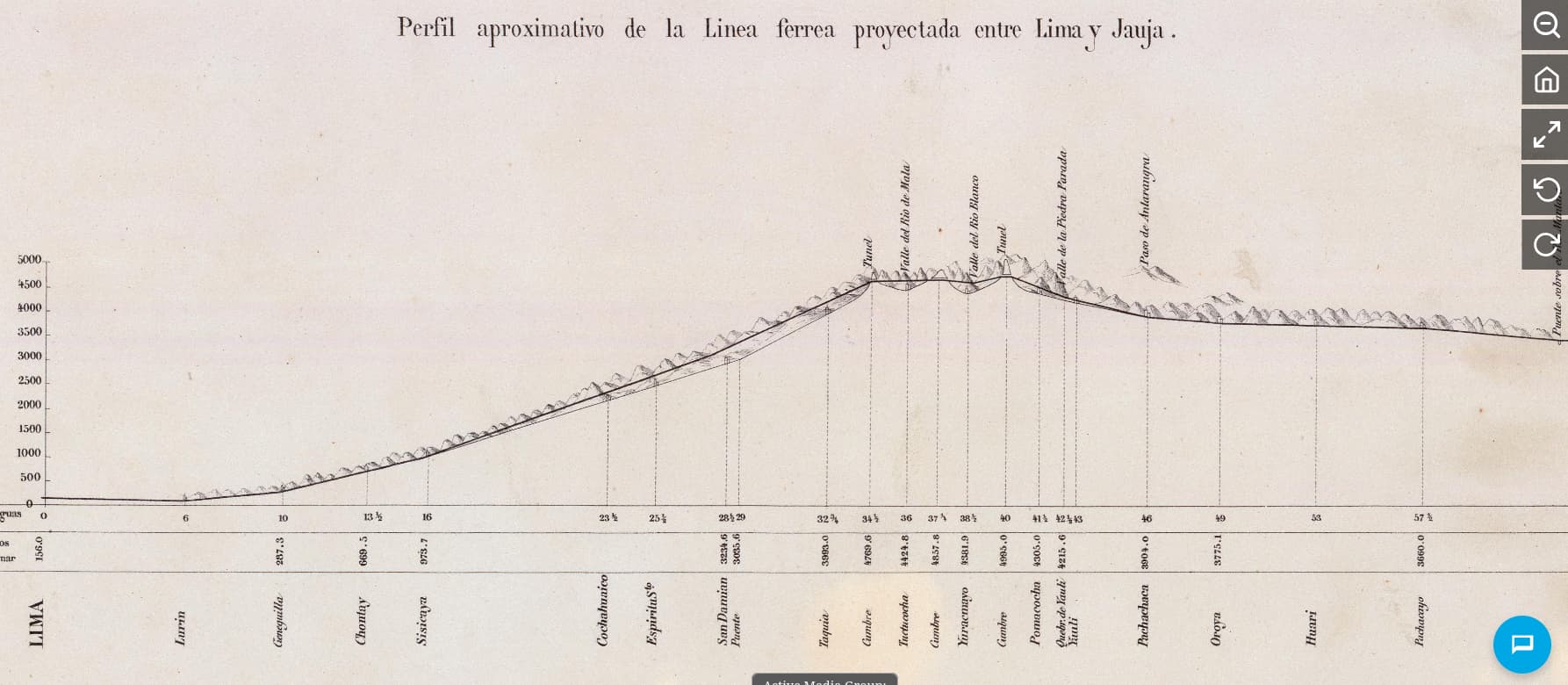
Here is the profile:


You can see the logic: the thin line, with mountains above it, is an idealization of the thalweg (valley-line); the thick line above it is a (simplified version of) the proposed rail. The simplest interpretation - is there a different one? - is that the rail goes up on a hillside cut well before the slope becomes too large; when the slope does become > 4% (in this map, after San Damian), it starts going gradually down to the valley floor, keeping a guiding grade of 3.5% or even increasing it slightly. It then tunnels, goes above a second valley (“Valle del Rio Mala”), etc.

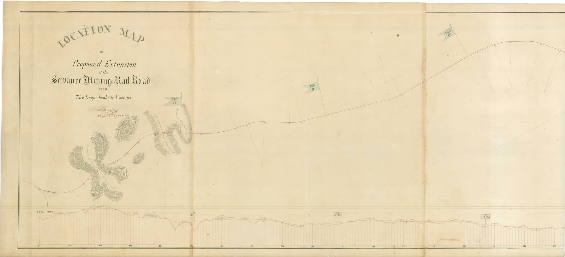
(The thin line/thick line reading seems to be confirmed by other texts from the time: an alternative proposal by Edmond Roy, Backus’s profile for the extension of the Sewanee railroad, etc. What is a thick line here would usually be a red line.)

Everything you are telling me is relevant, though in the following way. The plan that was actually followed was not Backus’s - either in the preliminary form you see here or in the March 1866 version that I hope to get from the archives in the summer. Rather, Ernest Malinowski - who came from an different tradition - French grandes écoles: Polytechnique, Ponts et Chausées - was put solely in charge of choosing the route, and also was at the head of the more than 20-year effort to executing the plan. He used every device under the sun, including plenty of switchbacks, a turntable, etc. As much as he and the engineers he led are respected for the execution (the train is still in operation as a cargo train) his route choice was much questioned at the time.

(The entire decision procedure was set in place by the notorious Henry Meiggs, who is said to have essentially ignored previous studies, and told the state “I will have one of your engineers (Malinowski) do a new study, and, if you grant me the commission, I won’t charge you”. my strong suspicion is that Backus acknowledged in March 1866 that there was a cartographic mistake in his map, due to inherited longitude errors, and that his plan was more difficult than it had appeared at first; Meiggs may have seen this as inconclusive - and I take that quick decisions were as much of his modus operandi as enormous bribes. But that’s a matter for another day.)

The matter has been mentioned in the historiography from time to time, but it would seem nobody has taken a real technical look at the what-if question since the early 1870s. So, I’d like to understand thoroughly what Backus was actually proposing, and what were the actual technical reasons against it. I also suspect some non-engineers involved may have misunderstood the proposal, though the gist of it seems clear just from the map and profile. That is why I am also asking whether it was unprecedented.

(Malinowski wrote a report comparing the two options, but it is only so useful: it reads like motivated reasoning, which it was. It was submitted - without a map or profile - only more than a week after the state put out a call for tenders based on his route choice. Malinowski mentions what would seem to be the strongest point against Backus’s plan only in passing, acknowledging that his route has the same problem. The entire matter was plagued with irregularities even by 19th century Peruvian standards, but that’s, again, another matter.

Edmund Roy, by the way, was a French engineer who criticized M.'s proposal and would have preferred a narrow-gauge line going above yet a different valley.)

See if this link works to pull the Backus map up directly:

I am not going to be of much use analyzing the actual valley-side grade from this map as I’m on a phone, but you might need to pull up or print one of the detail topo maps of the area that are also in the Rumsey collection and transfer the line of route to determine what might be the expedient line of cut that would yield suitably ‘close’ fill. It does not help that the lines drawn to indicate mountains are orthogonal to contour lines…

Believe me, I have been looking at topo maps (in Google Maps and from the Peruvian State) - or do you mean topographical maps from that time?

  • These are the Andes: the valleys are several hundreds of meters deep, between mountains. Perhaps I’m being dull, but I don’t see how anything other than hillside cuts tens of kilometers long would do. Of course that doesn’t look unreasonable to us - every highland road in Peru does that, and the better ones nowadays are probably straight enough for a 19th century train, while using techniques that would have been known and not terribly expensive at the time (cut-and-fill, small viaducts, small tunnels when one must). I wonder how such a plan would have looked at the time. (Peru had no reasonable roads to speak of at the time.)

Or is there an alternative?

  • If you look at modern topographical maps, you will notice what Backus must have noticed when he led a detailed second study: longitudes are stretched here, as inland longitudes and coastal longitudes have errors of opposite sign; this leads to the distance between Sisicaya and the place (mis)labelled “Espiritu Santo” being exaggerated, and the height of “Espiritu Santo” being exaggerated. In reality, there’s a nasty bit after “Espiritu Santo” (going north from 12°05’33.1"S 76°25’53.3"W, following the Lurin river) - Backus would have needed to pull some sort of trick from his hat to gain altitude there; a massive switchback might have worked, but perhaps there’s a solution that wouldn’t interrupt the continuous line. (Like what?) Backus once mentioned in Peru that he used zig-zags in Sewanee, but what I’m seeing in the Sewanee location map is some mild, well-chosen curves to even out the profile.