Dan, fortunately I haven’t gotten around to my renumbering after the second addition. This means I won’t have to shoot you. I’m waiting til the dust settles.[swg]
I dont have anything to add to this, but in my limited travels across the Mississippi, I have always enjoyed not only the railroad bridges, but also simply crossing the river.
Great job to you guys.
ed
Whenever I travel to Memphis I always try to use the I-55 Bridge so I can watch Rail traffic on the Frisco and Harahan Bridges.
Thanks for the help guys.
Dan-I still need 5 more to make 60.[:D]
Elliot-Would Dave Zuhn know when the SPB&T bridge first opened ?
I have added google links for 24 bridges. These have better pictures but you need to click on satellite.
Dale, he might. His model railroad is based on that part of the metro area, more so than mine is. He has done a good deal of research to create his design. If you’d like, I could ask him, since I had wanted to talk to him anyway.
I haven’t had a chance to look at the new pictures yet, I’m falling asleep.[|)][zzz][zzz]
Does anybody know how the “Huey P. Long” bridge handled Katrina?
Dan
I noticed in that first post that some of my photos came up in the search, I love this one: http://www.rrpicturearchives.net/showPicture.aspx?id=88481 that was a joy to make, lol. Try a keyword search on “Thebes Bridge”, more should come up…ahh…I did for you: http://www.rrpicturearchives.net/srchThumbs.aspx?srch=thebes+bridge .
wow–all I can say is that someone has done a lot of diligent work! we should all be
grateful for this excellent contribution. I am not familiar with the upper Mississippi. I
have crossed by rail at Newport, twice on the Milw Rd, at Ft Madison, Merchants, Eads,
and MacArthur at St Louis, both at Memphis, and Huey Long at New Orleans. I have
also used road vehicles by several where this was possible [some still rail have been
closed to vehicular]. is McKinley at St Louis closed to vehicular? We may need new
rail bridges to relieve New Orleans, especially if the Old River Structure fails and sends
the Mississippi out through the Atchafalaya 80 miles west of New Orleans. Several
geologists think this a real, even eventual, possibility.
Theo Sommerkamp crosstie@wowway.com
Having grown up in Memphis I have always been partial to the bridges of the lower Mississippi River. (Caro to head of pass south of New Orleans). The bridges are bigger , taller and the distance between crossings are greater. I have always told my non -railroad frinds that the crossings of the Mississippe River are the heart of the economey of middle America.
Hey nanaimo73, I have some new shots of #33 in Dubuque if you’re interested.
http://blhanel.rrpicturearchives.net/archivethumbs.aspx?id=7519
Thanks Brian.
I went to add them in and I ended up just adding this one by mistake.
http://blhanel.rrpicturearchives.net/showPicture.aspx?id=207431
Nice shot. Looks like you had a good day.
How does this bridge operate ? I would assume it is open for barges 90% of the time and CN has an operator there 24-7 ? Have you had thoughts of running across ?
Something like that would be easier up north.
There was a pickup truck parked immediately behind where I took that picture from, I assume it belonged to the operator. I walked over to the track and looked down through the bridge, and saw the operator standing near the middle of the second span, which rotates on the pier that it is centered on. I wasn’t going to even attempt to walk out there. I suspect that it does have to be manned 24/7, since if it’s open the operator is stuck out there, and there’s more barge and large boat traffic than there is train traffic on that bridge.
EDIT: I bet it’s not 24/7 starting sometime in late December or early January, for about three months! Extended vacations for the operators…
I’ve been trying to research bridge 29 in Winona,MN for about a year and have given up for now as the info is not out there. I’ve spent my summers of my childhood in Winona watching the trains cross the #29 swing bridge. I never knew #30 exsisted until a year ago as that bidge was on the eastside of town which is industrial. Actually my grandparents did live pretty close to it. My last visit to Winona in July gave me alittle more info on where to look for history on the town. So that will be part of my next visit.
http://www.mvr.usace.army.mil/Bosse/Plates/Plate16.htm
#38 Keithsburg, IL M&StL
I believe what remains of this bridge was constructed around 1912. You can see the piers nearby of the earlier Iowa Central structure it replaced. “Mile Posts on the Prairie” will tell you more if you can find a copy of this M&StL history. As a kid, I remember riding a jon boat under the bridge while a string of M&StL F units pulled an impressive length of freight cars overhead. Passenger traffic never figured large on this route.
The C&NW was quick to downgrade the Oskaloosa, IA to Peoria, IL mainline of the old M&StL. Around 1972, the line through Keithsburg was abandon. The bridge and a short stretch of track remained between Keithsburg, IL. & Oakville, IA.
The elevator in Oakville was reportedly interested in using the bridge to drop grain directly from hopper cars into barges. There was even talk of rebuilding track west to Morning Sun, IA and a connection with the Rock Island running between Burlington, IA and the Twin Cities. The Rock Island bankruptcy resulted in abandonment between Burlington and Cedar Rapids, IA. Nothing ever came of this rail to river transfer plan.
The M&StL bridge was an impressive vertical lift span. I say was.
Once abandon, the lift span was hauled up so barges could pass. In the early 1980’s, local youths decided to include the M&StL bridge in their July 4th celebrations. They scaled the lift span up to the the bridge tender’s shack and threw fireworks inside.
The resulting fire fueled by old grease caused the lift cables to fail. The lift span fell into the river blocking commercial navigation for several days. The US Army Corps of Engineers dynamited the lift span and removed the remains.
Other than the lift span, the M&StL bridge remains. Conversation with locals in a Keithsburg tavern over a decade ago brought up the Corps leaving the rest of the bridge in place since it was no hazard to navigation and could be quickly made capable of hauling heavy vehicles
I might have missed it in the forum, but did you note how long the bridges are? Which one is the longest and the shortest?
Here are 2 pictures of two differant bridges that I have visited.

Bridge 34 Chicago Milwaukee St. Paul and Pacific Between Sabula Iowa and Savanna Illinois
Bridge 43 Wabash bridge between Hannibal Missouri and East Hannibal Illinois
http://www.pbase.com/trailryder/random
Enjoy,
Later Bill
[quote]
QUOTE: Originally posted by nanaimo73
St. Louis
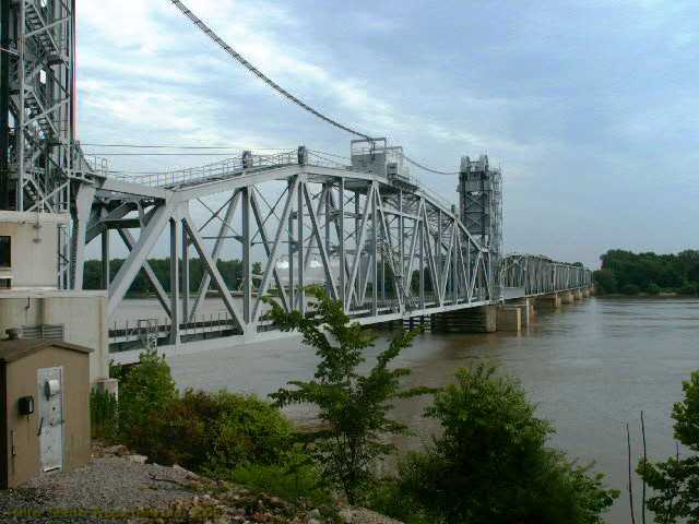
Bridge #46 is called Merchants bridge. It opened in 1890 and has been operated by Terminal Railroad Association of St. Louis since.
http://terraserver.microsoft.com/image.aspx?T=1&S=12&Z=15&X=931&Y=5355&W
http://maps.google.com/maps?ll=38.675158,-90.186961&spn=0.005045,0.009887
http://bridges.midwestplaces.com/mo/st-louis-city/merchants/
Amtrak uses Merchants bridge for Chicago-St. Louis trains
Status-good
St. Louis
Bridge #48 is Eads bridge. This was the first St. Louis bridge, opening in 1874. The Terminal Railroad Association of St. Louis was formed in 1889 to run the bridge. The last rail traffic was in 1974 and the bridge was traded to the City in 1989. The St. Louis Metrolink light rail system now uses the bridge. The Gateway arch is on the west bank just to the north.
http://terraserver.microsoft.com/image.aspx?T=1&S=11&Z=15&X=1864&Y=10698&W
http://maps.google.com/maps?ll=38.628999,-90.179418&spn=0.005048,0.009887
http://bridges.midwestplaces.com/mo/st-louis-city/eads/
www.asce.org/history/brdg_eads.html
127 b/w and 1 color photo of this bridge can be seen on the following website by searching “mississippi bridge” and going to #9
http://memory.loc.gov/ammem/collections/habs_haer/
Eads bridge was used by Amtrak for the National Limited until October 1, 1979.
Status-abandoned (by railroads)
St. Louis
Bridge #49 is named MacArthur bridge. This was built by the city because the other two bridges were owned by the TRRA. MacArthur opened in 1907 and was traded to the TRRA in 1989. A train can be seen on the east end of the bridge.
http://terraserver.microsoft.com/image.aspx?T=1&S=11&Z=15&X=1863&Y=10694&W
http://maps.google.com/maps?ll=38.614465,-90.184654&spn=0.005049,0.009887
http://bridges.midwestplaces.com/mo/st-louis-city/macarthur/
73 b/w photos of this bridge can b
http://reflections.mndigital.org/cdm4/item_viewer.php?CISOROOT=/army&CISOPTR=368&REC=4
I found this link to an 1889 photo of the Iowa Central Railroad bridge at Keithsburg, IL. From the looks of it, a 40 ton tractor trailer would strain its capacity. This bridge was replaced around 1912. The cut stone piers of the first bridge are askew, but still visible next the abandon 1912 structure.
Sorry to intrude, but I am very lost! Will you guys please help a pitiful single mom here? I need to know where to go to learn how to start with trains. I would like to buy my 8 year old son a starter set for Christmas, but I want to do it right! I hope it will be something he enjoys for years. Thank you so much!
Again, BIG sorry! Posted my request to the wrong place. I am looking for MODEL trains. ![]()