I’m trying to locate a fictitious short line between the Santa Fe and the Southern Pacific railroads during the 1950’s. However, I have been unable to find any railroad map sources that aren’t expensive or only provide antique maps from the late 1800’s. Does anyone know of a good source for a Santa Fe and/or Southern Pacific system map in California? Thanks for your help.
Go to the BNSF website (http://www.bnsf.com/tools/reference/division_maps/div_ca.pdf) for a modern system map of the BNSF in southern california, which for California is a good first appoximation for the Santa Fe, especially in SoCal. Any of Signor’s books would help with the SP once you have a specific area in mind.
However, you’re sort of pushing a wet noodle, so to speak, since any likely interchange between the two would have been at Tehachapi (joint use track) or in San Bernadino/Colton area. However, a good possibility would be a theoretical shortline from Lancanster/Palmdale to Cajon area if you date it prior to when SP actually constructed it. Or, look into the SJVR in the central valley as it could be a good approximate prototype.
Jack W
There’s a book called “Railroad Maps, the West”. It might be useful. There’s a copy on Amazon.
Ed
Hornblower,
You do not indicate which part of California you are interested in though examples of shortlines do exist, even ones jointly owned by the two roads. Joint operations/ownership applied to the Sunset Railway out of Bakersfield. This line featured very late steam operations under the SP, with SP twelve wheeler 2914 still in a park in Bakersfield. Further north, the Central California Traction, CCT, (Stockton to Sacramento) fell into joint ownership by SP-ATSF-WP as a consequence of attempted buy-out by the SP. Dave Stanley has a great relatively new book on the CCT. Tthe Northwestern Pacific (Schelleville and Napa north to Eureka) was jointly owned by ATSF and SP in the first part of the Twentieth Century. there are examples of other shortlines (e.g., Visalia Electric) that could give you similar inspiration.
As to maps, you might start with the Steam Powered Video (SPV) atlas for California. SPV’s atlases capture the pre-merger line ownerships. that certainly will give you a better idea of the proximity of the two roads in both the LA Basin and the San Joaquin Valley up to the SF Bay Area. The two most relevant books by John Signor on SP operating divisions are his book on the Western Division (Oakland-Sacramento) and the Tehachapi Line.
Good Luck!
As others have mentioned, the SP/ATSF jointly-owned Sunset Railway in the Bakersfield area is an example of a shortline that connected to both, although it was operated by each of the parent railroads in alternating 5-year shifts into the 1990s.
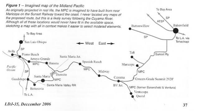
At one time, I was planning a proto-freelanced extension between the Bakersfield area (SP &ATSF) and the SP Coast Line near Pismo Beach and on to Avila. The route would have generally followed CA Highway 166 from the Sunset Railway near Maricopa to the coast. This line was actually proposed in real life in the early 20th century as the “Midland Pacific” and some roadbed was graded, but nothing ever came of it.
An article I wrote on the N scale layout design project and the imagineered prototype was published in the Layout Design SIG’s Layout Design Journal #35, December 2006. The imagined map from that article is shown below.
In the center of the state, the Central California Traction (owned by the SP/ATSF/WP in the 50s) and the Sierra Railroad (whose freight operations are now called the Sierra Northern) are interesting candidates. The fine recent book on the CCT has been mentioned earlier and there was an article on a John Armstrong design for the Sierra in Model Railroader, May 2004. Another Central Valley shortline is the Modesto and Empire Traction, which sits astride the former SP and ATSF and was covered in an excellent two-article series by Trevor Marshall in the October and November 2007 issues of Railroad Model Craftsman. In the northern part of the state, the Northwestern Pacific was jointly ATSF/SP owned, then
Thank you all for your great referrals and ideas! Byron’s short line is pretty close to what I wanted to do. I hadn’t really settled on any specific area of California although the double level shelf layout I’m planning pretty much ruled out mountain railroading. An agricultural valley would allow relatively level track. I had an idea to model the area where I grew up and Jack’s link to current BNSF track maps sealed the deal. I grew up in Huntington Beach, most of which lies in the alluvial plain of the Santa Ana River. I remember a spur line of the Southern Pacific running all the way to the beach at Lake Street as late as the '70s. Since Huntington Beach was an oil boomtown and oil was still the area’s greatest asset in the late '50s, I had one major industry to model at a somewhat believable interchange point.
I have always been fascinated by the huge blimp hangars still standing at the former Tustin military base. I figured these hangars would make great background structures, plus the military base could be another industry. The fact that BNSF still owns spur tracks near this base meant I had another interchange point. In between my two fictitious interchange points were about 10 miles of agricultural land (now all housing) although I could not find any reasonable excuse to locate a railroad straight across this valley. Further research uncovered a little known short line called the Santa Ana and Newport that ran from Santa Ana down to McFadden Wharf in Newport Beach along what is now the SR 55 Freeway and Newport Blvd. This line was bought out by the Southern Pacific only a few years after it opened and the line was abandoned soon after when a freak storm did significant damage to the coastal areas. However, had this line remained independent and survived at least into the fifties, it could easily have added a line from Newport Beach up the coast to the Huntington Be
Sounds like fun! I’m sure at least some of us would appreciate you sharing the track plan you adopt.
Mark
Mark,
I’m sure it will be more fun than the totally freelanced layout I was planning. I’ll need to do some redesign of my track plan to better fit certain locations. Another fact I learned since my last posting is that the Pacific Electric had a line connecting Long Beach and Newport Beach along the coast – right down the route I’d like to use. Since the PE abandoned this line in the '50s, why not assume that the fictitiously surviving Santa Ana & Newport purchased the line for a connection to the Huntington Beach oil fields? The other plus to using an actual location is that roads have purpose.
Chris