K.P>, would you surmise that the bents in the foreground are newly installed? The wood looks old, but looking at the Google Earth view of the bridge I see no evidence of bents to either side of the bridge as of a year ago.
ChuckCobleigh (2-22):
For forty years I’ve driven over the San Jacinto Branch on what is now I-215 on the east side of Perris, but never managed to follow the rail line itself, except in the last several months. So, I’m not sure what the history is of the bridge in question.
All the mapping aerials I checked show a view the same as the photos previously posted. What I did find, however, was the Google “Earth” mode you mentioned was, because of the sun angle, kind of illusionish, and not definitive.
Maybe someone at the forum was fortunate enough to have passed the bridge many years ago and could shed some light on the matter.
Take care,
K.P.
I think I figured out what I am seeing. After looking at the Google Earth Street View of that part of Case Road, I realize that what I was seeing as separate bents is actually the bridge bents themselves, the cap beams of which extend a goodly distance beyond the deck. So much for my suspicion that they had started working to put a second bridge in already.
Once the I-15 route was completed between I-10 and Cajon Pass, I have had way fewer opportunities to sample the I-215 route.
ChuckCobleigh (2-22a):
It is amazing how different minds see different things (interpretations) when looking at one matter. One advantage I had about the bridge adjacent Case Rd. was seeing the bridge in person, which avoids have to ‘interpret’ a scene from a photo.
It is assumed a replacement bridge over the San Jacinto River will be built. Putting in such a new replacement bridge on an active rail line is a show in itself. But, there is not much rail traffic at the site, which will greatly expedite the logistics of a replacement.
On September 1, 2008 the following Sunset Route photo was taken at Thermal, CA, near Indio.
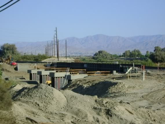
On April 25, 2009, the new bridging was in service. But, the key point is that the other main’s bridge had pre-stressed bridging laid within the old bridge!
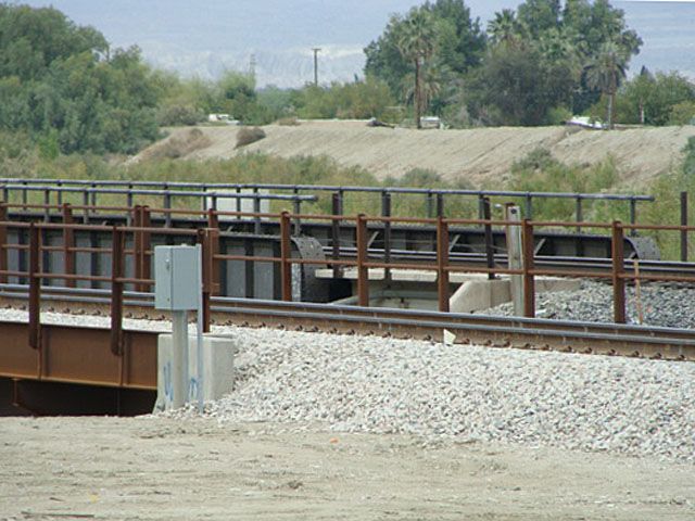
Obviously the bridge in Perris is different. It is wondered what logistics and science will be employed in replacing it.
Best,
K.P.
Along I-215 North of Perris, CA
If you started Hi-Railing from the Perris Depot northward, your Hi-railing experience would be short lived!


Along I-215 a short distance to the north of the above photos, something would block your way. And, there is also something happening out that way too that caused BNSF to station a mobile unit by what was happening!
A six-part series on all this will be posted either later today or early tomorrow.
Update as of Monday, March 11, 2013
Along I-215 North of Perris, CA
Surprise Developments
Part I (of I-VI)
Intermodal double-stack well-cars have been parked in long sidings on the ex-Santa Fe San Jacinto Branch of late. However, a new development has arisen. They are now parked right on the branch itself, making getting to the far end of the branch not possible. Maybe there are no customers at the far end anymore.
Three elevated views by the Nuevo Rd. overpass area just before the sun rose:
Looking south:

Northward views:


The well-cars’ north end:
Update as of Monday, March 11, 2013
Along I-215 North of Perris, CA
Surprise Developments
Part II (of I-VI)
Nearby (to the above) a contractor and its vehicles, including a small crane-type truck, were present to take down billboard structures right by the track. Here, the freight track (far right) will remain, and a new, high speed track for Metrolink will be laid. The far right pickup truck had orange BNSF decals! Hence, this track may still be dispatched by BNSF dispatchers.

A closer view:

Continued in Part III
Update as of Monday, March 11, 2013
Along I-215 North of Perris, CA
Surprise Developments
Part III (of I-VI)
Later that day, in the afternoon, K.P. had about 40 minutes free time right in that area, so returned to the site, and the sign was down, and workers gone.

The sign post with the double-stack well-cars in the distance.

The Nuevo Rd. overpass is in the background.
Continued in Part IV
Update as of Monday, March 11, 2013
Along I-215 North of Perris, CA
Surprise Developments
Part IV (of I-VI)
Looking north from the Placentia St. overpass: One additional sign was on the ground, and another was being prepared for being put on the ground

A closer view:

Note the proliferation of tracks to rail customers on the left. There are no such customers on the right because Highway 395 / Interstate 215 used to parallel the track quite close.
A view looking south from Ride St.:

Continued in Part V
Update as of Monday, March 11, 2013
Along I-215 North of Perris, CA
Surprise Developments
Part V (of I-VI)
Ride St. used to go through, but hasn’t for many moons. The background barricade will have to be moved or eliminated to lay another track. An 18-wheeler passes on the paralleling I-215 Freeway.

A northward view of the track that will remain, with a new Metrolink high speed track to be laid on the background right-of-way right:

Continued in Part VI
Update as of Monday, March 11, 2013
Along I-215 North of Perris, CA
Surprise Developments
Part VI (of I-VI)
A northward view from the other side of the track, from the frontage road:

Another northward view: Note the nearby downed billboard on the lower left.

The signs are laid right by the roads.

This will conclude the “Along I-215 North of Perris, CA” series.
I realize that renting the air space above the tracks is a revenue source to railroads (think Grand Central Station) but it does not do much for the beauty of nature. The bill boards are a blight on the landscape and I am happy to see them going. Besides they can block the view of the trains. In Texas a law was passed limiting bill boards along freeways. Immediately several signs went up before the effective date of the law in an open field where a freeway was planned to be built in the future. Talk about blight and skimming around the law. A few years ago someone was hitting bill boards with a chain saw (wooden posts) at night and fell several signs on an Indian reservation. More power to them. Hope they were not caught in the act.
I’ma not a great fan of billboards but I would rather see billboards then watch 18 minutes of advertising per half hour on TV. The only reason they are being taken down is either the permit ran out or it isn’t seen as being profitable to have them in this location… OR… look for bigger better ones to replace them. I suspect all three.
I might add here taking the law into your own hands is still against the law. However, what would a bunch of outlaws be, if they didn’t break a few laws.
There is one way to find out who is dispatching a certain section of railroad…turn your scanner on. It will be apparent with the next local… in switching the spur.
Keep the reports coming K.P. Most of the time your assessments are right on. Yes sir, most of the time, grin.
BarstowRick I also do not like the 18 minutes of commercials per hour on TV. We get around this by recording shows we like on our Directv box and playing them back at our leisure. The nice thing about doing this is you can zip through the 9-12 commercials per break in a few seconds. This reduces an hour program down to 42 minutes. Also if you miss something you can replay a little bit and also pause for nature calls.
I have no idea who was felling the billboards on the Indian reservation, but I do not think too many tears were shed on their passing. I would never do this myself as it is a felony even though how revolting the billbosrds are. Do not think this would be a good defense if caught.
K.P., thank you for your update on the Perris Valley Line from earlier this week.
I’m of the mindset (similar to people in this thread and rdamon in the Sunset thread) that these felled billboards will be replaced, perhaps with electronic billboards. Currently in the city of Los Angeles, there is an interesting controversy involving electronic billboards.
Also, the fact that the judge has (to my knowledge) not yet ruled on the lawsuit involving the Perris Valley Line, makes me a bit surprised that this work is occurring.
The question that comes to mind, if you don’t mind my speculating? Are they clearing a R.O.W. for the new high speed track and leaving the old switching line in place. There is a picture K.P. has shared with us that shows a number of left handed switches. It would be costly to replace these with high speed switches. Not to ignore the local, while it is in working and the need for the commuter trains to get around them.
Just a thought.
CCLTrains, thanks for the come back and dully noted. I like the magic box you mentioned. What you don’t know is I’ve practically eliminated all TV watching…getting sick and tired of it. No cable boxes in my tin can of a home.
Belated Victory Report
This probably escaped most of us, but back on February 6, 2013, the Press-Enterprise newspaper reported Ames Construction, Inc. was the low bidder and won the contract for all the grading and culvert-work for the Perris Valley Line (PVL).
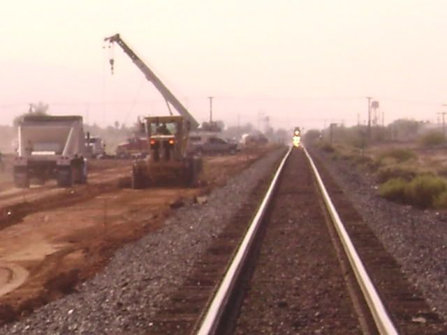
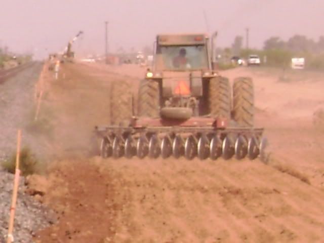
Ames Construction just finished a Union Pacific Sunset Route grading job in the Niland, CA area east of Salton Sea.

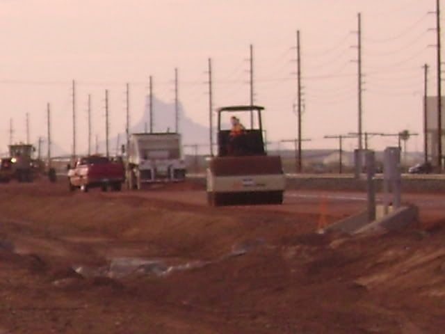
It was the Sunset Route contractor on the two-track grading work in Arizona, of which these photos of that work were taken between Casa Grande and Toltec, shot on August 5, 2008:
The Press-Enterprise PVL story:
LINK:
Ames Construction Company is also the contractor for Interstate 10 reconstruction and removal of the Union Pacific Pantano bridge at the Cienega Creek / Marsh Station Road area in Arizona, fulfilling a $17 million contract with the Arizona Department of Transportation.
Replies:
ccltrains (3-14), BarstowRick (3-15), mvs (3-15):
The Fontana, CA area billboards on the Sunset Route that were taken down in recent times have not been replaced. I question whether they ever will. Concerning the billboard removal on the Perris Valley Line (PVL), I don’t see them returning either.
BarstowRick (3-15/3-15a):
No, they are not clearing the right-of-law at this time, but I expect that in the future.
All those old switches I understand will remain.
mvs (3-15):
Personally, I don’t think the judge in the lawsuit would side with those that brought the lawsuit. It is an existing, active rail line, so, from that perspective, I don’t think those that brought the suit have a leg to stand on. But, time will tell.
cacole (3-16):
Ah, yes, the Union Pacific Main 2 reroute by Marsh Station Rd. in Arizona. Good comparison. Note the next item …
Comparisons
On Saturday, March 16, 2013 K.P. was on assignment in the Palmdale, CA area, far away from the Perris Valley Line, and did some documenting of Metrolink’s Antelope Valley Line for comparison purposes. A post series is thus in the works, and it will give the forum added perspective about the PVL mountainous Box Springs area. Timely was cacole’s mention of the Marsh Station Rd. area of Arizona, a mountainous area also, and that is planned to be brought into the post series for comparison too.
Moving Mountains
That will be the theme of an eleven part (A-K) posting series, comparing future track relocations on the Perris Valley Line with what was done in Arizona recently and in Southern California in the last 35-40 years or so.
The material is all ready to go, but making a slot of time for the posting is expected later tonight, between 9:00 P.M. and midnight, Pacific Standard Time.
Severely delaying the posting has been new ways at photobucket.com, and at this point it is unknown exactly what approach is going to be taken to deal with those new disruptive ways.