I wonder if someone have any pictures of Bond in Colorado, where the yard is? The best would be if someone that happens to read this live there, but that is maybe asking too much. [:D] I’m trying to learn how the scenery looks there.
Electrolove,
What part of Co. is/was Bond in? It doesn’t show on my map. If my friends out there are nearby I can ask them to get some pics - otherwise maybe when our local guys are out there in Sept. regards, J.R.
We continue the journey from the west portal of Moffat Tunnel, traveling through the Rockies. Station stops are made at Fraser and Granby, Colorado and the scenery changes from alpine to canyons. Canyons include Fraser, Byers, and Gore as we follow the Colorado River to Bond, Colorado. We also pass one eastbound train.
If that makes any sense.
Update!
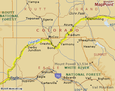
I found some more info now. It seems that Bond is located somewhere between Yarmony and Orestod.
El, Not much to see , the Town of Bond is just a wide spot in the road. There are some Siding south of there that they use to tranfer cars. I have a friend that is a Engineer for the UP that drags emties up to Bond. There is a more substancial yard nort in Phippsburg,Co.
Bond is about 1/2 way between Steamboat Springs and I-70 on Route 131. I used to live in Steamboat and traveled through there weekly. I fi ever get up that way i will see if i could get some pics.
You might try this link and see what you can find on it http://www.drgw.org/
This site is loaded with DRGW info.
Good Luck
Marc
El,
Found it on my map as well - it’s just not in the index and I don’t see that well anymore. That is near the area we tour for the Colorado Grand, a thousand mile road tour with vintage sports cars held each fall. It is IMHO the most beautiful area of this country. I will look through my photos to scan, and see if my friend from Denver has been out that way. What a great location you’ve picked to model! regards, J.R.
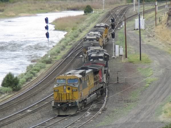
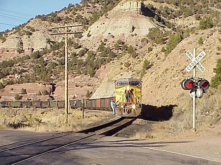
I really love these Bond photos. I don’t know the exact location, maybe someone can tell me where the two photos belong in the map. Just wanted to show them so you all know what I’m talking about [:D]
I was trying to envision where the UP consist in your pic might be in relation to the curves in the river. It looks like a great place to model, mountains and the river! Man, those three head signals are elaborate. Are those Grande or UP implants?
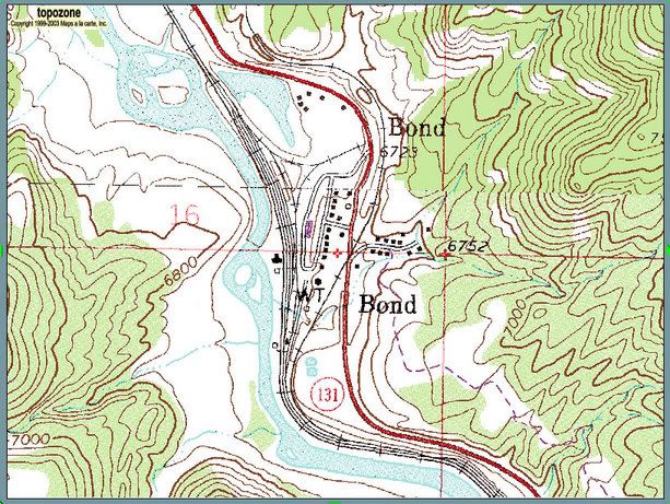
Alot of the trackage can be seen. It depends on when the USGS updated the maps and what’s there now. It’s a neat tool for rail buffs though. Topo maps give you a 3D “feel” for the topography surrounding a scene. Hope it helps you with your yard!
I believe the first picture is taken looking North almost from where the circled 131 is on the map.
I believe the second photo is also looking North taken at the only point on the map were the RR crosses the red highway.
Another observation. I was coming south on the highway and that spur crossing the road and going up the mountian looks like a zillion percent grade. When I first saw it I would not have guessed it was a railroad grade becase it looked so steep.
That Crossing is on the river road between Bond and Sweetwater, The road is called the River Road. The road ends at Dotsero On I-70, the Tracks connect with the Route through Glenwood Canyon. This is the same Route that the California Zypher takes.
Those photos of Bond are looking west, where the branch to Craig takes off from the main line. The Craig branch is part of the original Denver and Salt Lake line constructed by David Moffat. The second picture shows a train coming east off of the Craig branch to the junction with the main. I could be mistaken, but I think the grade is about 2.2%, ascending and since the grade heading west on the main is descending at about 1.2%, the difference looks REALLY steep by comparison. Dotsero, a few miles west, is considered the point at which the Rio Grande built their connecting line from the Moffat Road to Orestod, where it connected with the Tennessee Pass route toward Glenwood Springs and Grand Junction. However, the junction with the original Moffat Line (Craig Branch) is at Bond. Though UP doesn’t run many freights over the Moffat Line between Salt Lake and Denver, the Craig Branch generates quite a few coal trains off of the Craig Branch, so the portion between Bond and Denver is still pretty active. As to the location on the map, the first photo would be just north of the circle with the 131 in it, while the second is a little further north, just about where the dashed red longitudinal line cuts through the map. That thick red line curving through the map is the state highway, while the thinner black lines are the railroad tracks. There are quite a few videos available of both UP and Rio Grande power on the Moffat Line, and Bond seems to be a favorite photography spot. You might want to check out a few videos and see what you come up with. The area is really pretty.
Tom [:D]
Ok, that sounds great. I would be very happy if you could take some great pictures when you are there. Looking forward to hear from you again after the trip.