Looking for some good resources on how to model railroad maintenence roads. Any ideas step by step would be good. I model ho sCale Rio grande Moffat to grand junction. Thanks
Hi,
The ones I’ve seen in Colorado/New Mexico were all dirt with gravel added in some places. They went from highways to trackside and paralleled the track to storage sheds or the like. I believe that handcars were often in these sheds, allowing the track crew to pull the car on the track, and go to wherever maintenance needed to be done.
Your best source of usable information might be Google Earth. Start at one of the points you’re interested in, and zoom in for a very close look to see what is beside the track.
Here in Arizona it’s usually just a dirt road paralleling the track, with a locked gate at the entry points after 9/11.
I have several such roads on my layout and have posted photos of them here on the forum before.

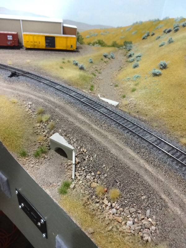
These roads are fine sand with tire tracks of dry-brushed acrylic craft paint.
Maintenance roads do not necessarily parallel the right of way for long distances. This (concept) prototype photo could be used on a layout with a smaller footprint to be modeled.
Note the East Portals of the Gallitzin Tunnels including abandoned trackage, abandoned tunnels, multi-elevation tunnel portals, steep road access, and track overpass of the maintenane road. Here’s the main page to the Gallitzin Tunnels.
Those are great roads thats exactly what im looking for could you give me a little more information on the process you used for modeling these roads. Thanks
They’re pretty simple. I brush diluted glue onto the scenery base and apply the fine sand over that, ensuring the future road area has appropriate textures (i.e. no oversized particles). Sometimes I’ll add a slightly different texture or color of sand/dirt along the center or edges of the road to represent material that’s been kicked up by passing vehicles and thrown out of the path of travel. Once the glue is completely dry, I finish the tire track areas with light a dry-brushing of acrylic paint, often making several passes. The paint eventually fills some of the spaces between particles and looks like compacted dirt.
In some places in South Dakota, the “maintenance road” is flat ground near the tracks.
Fun to drive at night when you’ve never been there, let me tell you. You have to trust that the train crew knows what they’re talking about as you drive the crew van through 3’ high prairie grass.
Thanks for your help I will try that on my layout.
While it won’t help you with the actual scenery work, you will find official specifications on pgs. 35-36 of
Something to keep in mind for scenic interest, is that many of these roads are ex-roadbed from when there were more tracks. Culverts, bridges, even tunnels can carry the roadway.
Here’s a picture from my neighborhood:

(apologies for the giganticalness)
Back in the old days, this was the southern approach to the huge and busy Potomac yard. When they pulled up the yard, they dropped from four tracks to three (they still needed the capacity for commuter trains and station stops). They plated over the bridge decks so trucks can cross the overpasses. There’s footings of old signals, sheds, and all sorts of things that are placed as if there was a fourth track there, so you don’t need to make the road zigzag around. And the new signal bridges are build to span four tracks, so the road can go right under them.
In the next 10 years, that’ll end up being a fourth track again anyhow.