News Flash – Dateline 1884 – Commodore Vanderbilt, Andrew Carnegie and a group of partners from Pittsburgh have just annouced the formation of a new railroad company called “The Southern Pennsylvania Railroad Company”, whose mission will be to provide alternative rates and transportation routes to the businessmen and people of Pittsburgh PA to all points south of the region. The company’s first order of business will be to send out site surveyors to determine a suitable route…
… and the journey begins!!!
I have finally selected a route-- I’m modelling the South Penn, from Pittsburgh PA to Harrisburg PA, the route that is now the PA Turnpike. I will be modelling it sometime in the timerange of 1955-1965. Still mulling that one over a little-- but probably in the early 60’s I’m thinking. Before Penn Central.
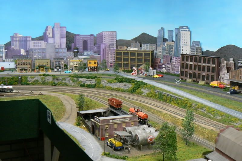
Now that my wife, er-- “the commission”-- has determined that its acceptable to open up the wall in the basement, I have seen the vision of my railroad. For folks that have been following along or would like to, here is a link to an earlier planning document which shows the modeling arena, proposed mainline, and general layout of the space. Some of the ideas will be a little different-- rearranged mostly to fit the new concept. [url]http://www.wizard.org/ModelRR/Layout_Plan_20080701.jpg[/url.
Looking at the image of the area (see link) I am now able to open up the top two areas (top left & top middle) which permits me to do a more interesting layout. Overall mainline will be about the same, but instead of having two weakly-modeled towns on each end, will model Pittsburgh and Harrisburg back-to-back. Each will be the backdrop for the other. Harrisburg will be the view facing the observer as they walk into the layout room and will begin in enola yard and take the low-line across the bridge over the susquehanna, around the layout, up through the mountains to the high-line and on through th
Hi jw: Yay! another Pennsy layout in the works. That looks like an ambitious project, but doable. I considered modeling that same area, but decided to model the area South, Columbia, Pa. area. When you are ready for back drops, you may want to consider using these for Pittsburgh. They are available at Scenic Express. Here’s a pic. . Good luck with your project.
Actually there was never any question whether it would be a PRR railroad, only which route!
Also your layout looks very familiar-- I’m pretty sure I’ve either stumbled across your web site before or else you’ve posted more of your pictures on this site before. You definitely have a nice looking layout going there.
In 1884 it would have been singularly impossible for Commodore Vanderbilt to have announced anything since he had been pushing up daisies for seven years. William H., on the other hand . . . . . . . . . .
. . . . . . . . . . and for what reason, pray tell, are they sending out surveyors?; I thought that this route had been surveyed by the Army Corp of Engineers about forty-four years earlier!
You are correct, it was William, I typoed You are also correct that it had been surveyed by the Army Corp of Engineers in the 1840’s. However, according to the various sources I’ve found there were actually three separate route surveys performed in preparation for the railroad-- the other alignment would have taken it down to Wheeling WV.
congrats on finding a pennsy route to model! You know when you’ve finally find the theme when it hits you like a ton of bricks! i have been searching for a few years to find a era/theme to hit me like that, and recently i found one…the southern new england railroad.
fortunately for me the roadbed and bridge abutments for the never built railroad can still be found in various locations. I never have researched the railroad you are modelling, but maybe if you do some research you can find drawings or sketches from the amy corp survey crews. maybe you would be able to get reprints of these…would make great conversation topics at an Ops session or gathering!
Best of luck with your efforts, and i’m sure with a theme such as the one you have, it will keep you entertained and satisfied for years to come!
I’m wondering why you changed the parent to the PRR from the NYC. It kind of eliminates the rationale for having the road in the first place. (Which is why in real life when the PRR swapped the West Shore for it, the South Penn never got past a roadbed.)
The late Bill Schopp, RMC’s LAYOUT DOCTOR, did a South Penn trackplan way back in the 1960s; I can’t remember whether it was there or not that I found out that the Army Corps of Engineers had originally surveyed the route; whatever is the case I encountered the info somewhere.
Its true that it was originally begun by Vanderbilt, Carnegie and the Pittsburgh group, however, as you pointed out, JP Morgan brokered a deal whereby the Pennsy gave up the North Shore RR to the NYC and NYC gave up the South Penn to the Pennsy. I choose to model the “what if” question from a Pennsy point of view.
I’m wondering why you call the NYC the “NYC” instead of the “Mohawk and Hudson” ??? [;)]
The Pennsylvania Turnpike map sure looks like the South Pennsylvania Railroad map…
“The turnpike was partially constructed on an unused railroad grade constructed for the aborted South Pennsylvania Railroad project, and six of its seven original tunnels (all tunnels with the exception of the Allegheny Mountain tunnel) were first bored for that railroad.”
P.S.: Any small towns could be named after one of the six bored tunnels from the actual South Pennsylvania Railroad which are generally named after the mountain ranges.
Neal Schorr built a neat layout a while back based on the South Penn as if it had been built and survived into fairly modern times. The index shows the articles as Model Railroader May 1990 (which I haven’t seen) and April 1997, which had the full extent of the trackplan. By the April 1997 article, Neal was operating it with Conrail equipment. He’s moved to a different era and modeling focus now, but it was a very interesting layout.
Yes, I saw one of the articles and know of the other (I have it here someplace but haven’t read it yet). That was one of the excellent background items that helped me decide that this was the right path for me. I like having the prototype railroad (pennsy) to draw inspiration from and at the same time a virtual blank slate on which to construct my own vision of “what might have been”. Plus its been a lot of fun researching and discovering what other variations of the South Penn have been modeled.
Niel Schorr’s South Penn (been in Model Railroader a couple of times-- this site though does not do him justice-- his old South Penn layouts in MR were fabulous!): http://www.hirailers.com/neal_schorr.htm
Interesting note…you can add in some narrow gauge action as the East Broad Top had planned to expand soutward to meet the South Penn Railroad via their shade gap branch!
In 1876 a section of track called the Rockhill Iron and Coal Tramway was built into Blacklog narrows as far as Groves Quarry to provide raw materials for the iron furnace. It serviced ore mines in the narrows and hauled limestone from Groves Quarry just east of the narrows. Expansion into Shade Valley had been planned since 1875, but did not materialize.
In 1883 in retaliation for the acquisition by the Pennsylvania Railroad’s acquisition of a line paralleling the New York Central in New York, the NYC commenced plans to build a line across southern Pennsylvania to compete with the Pennsy. In 1884 the EBT, in it’s excitement to become a bridge line between two major carriers and reap revenue from building material transportation, began grading for track to meet the South Pennsylvania Railroad. To insulate the EBT finantially, the branch was built under the aegis of the Shade Gap Railroad Company. From the Rockhill Iron and Coal Tramway, the branch departed at the west end of the narrows, proceeded down Blacklog Valley and through Shade Gap. It then went west to Neelyton then south towards Burnt Cabins where it would meet the South Penn at the western poratal of the Tuscarora Mountain Tunnel. By late 1884 rail had been laid to Shade Gap and trains stared in early 1885. When the railroad war was ended and the South Penn stopped construction in July 1885 the roadbed was complete to Burnt Cabins as well as a yard site near Tuscarora Tunnel and timbers ready for needed trestles like the huge one over the valley at Burnt Cabins. In 1886 the branch was put to some use by building north from Shade Gap along the east side of Shade Mountain to the Rockhill Iron and Coal mine at Stair, and subsequently to Goshorn and Richva
 . Good luck with your project.