It sure did, and its servicing facilities were the closest to Dearborn Station.
Rich
It sure did, and its servicing facilities were the closest to Dearborn Station.
Rich
B&O Observation cars, on their observation end were equipped with a brake valve so whomever was ‘protecting the shove’ had control of the air brakes on the train to facilitate backing the trains into stub end tracks.
Riding the B&O Capitol Limited on numerous occasions I witnessed a uniformed trainman operating the brake valve as the train was backed into Washington Union Station as a normal matter.
The Archer Avenue yard was only about a mile from Dearborn. By contrast, C&NW and MILW’s yards were about 3 miles out, 51st St was about 5, NYC’s 61st St. was about 7, and IC’s loop about 9 miles away from their respective stations.
During B&O control of the Alton (before GM&O), the Alton’s trains were serviced at B&O’s Robey St. yard. Trains were wyed and then taken out to Ash St crossing before backing south onto the B&OCT and heading north to Robey Street. After B&O control ended, the trains were serviced at the GM&O yard at Brighton Park near Ash Street.
The Alton (and later GM&O) was the tenant at Union - the station was owned by CB&Q, MILW, PRR and PCC&StL(PRR), resulting in PRR owning 50%. PRR successor (via PC and Conrail) NS still has freight rights to the North Joint approach (PRR+MILW), though the last customer there closed a number of years ago.
In my comment, I am stating that it should not be expected that the railroad trackage is accurate. This is something that has been stated repeatedly in track planning articles and is well known by people who use the maps regularly. Building dimensions are accurate, and the primary building construction, denoted by the color, is also accurate.
That’s not entirely correct. Earlier you stated that the maps very accurate for their purpose which was documenting structures. Academic sources have pointed out that while Sanborn maps are generally accurate and consistent across different years regarding structures, the viewer may find some minor discrepancies in building dimensions. As further noted, these discrepancies usually result from differences in mapmaking rather than changes to a building. That is pretty consistent with your contention that the maps portray misaligned, disconnected and orphaned tracks.
Perhaps I should retract my earlier encouragement to model railroaders to consult Sanborn Fire Insurance maps since they cannot be relied upon to determine the exact dimensions of buildings and other structures, and given the possibility of misaligned, disconnected and orphaned tracks.
Rich
The amazing thing about downtown Chicago passenger stations was the distances between the stations and the coach yards and engine servicing facilities.
Rich
Did the Alton use Union Station or Grand Central? I am not aware of a convenient route between Robey Street and Union Station (I don’t know enough about all the various connections that exist in and around Chicago.)
Yep, the Santa Fe facilities were close to the station compared to the five owner roads.
Rich
Chicago Union Station (CUS).
Rich
To the best of my recollection, 24 railroads came into downtown Chicago using six different stations.
CGW, Soo, B&O, BOCT
CRIP, NYC, NKP
PRR, C&A, MILW, PM, CB&Q
C&NW
CWI, C&EI, GTW, Wabash, Erie, Monon, AT&SF
ICRR, MC, CCC & StL, C&O
Depending on the sample year, some railroads moved around. Some examples and a handy list of railroad abbreviations below.
PM used Grand Central, even before C&O control. B&O and C&O(PM) moved from Grand Central to C&NW’s CPT in 1969. PM’s route involved both LS&MS(NYC) and B&OCT trackage rights.
MC trains moved from Central to LaSalle in 1957 - except for the Wolverine, which had run to/from LaSalle since some time in the 1930s. Big Four trains stayed at Central. After the Penn Central merger, former Now York Central trains moved from LaSalle to Union.
IC’s suburban trains terminated at Randolph Street in both the steam and electric eras - except for the few Iowa line suburban trains which ran from Central as the track arrangement would not allow them access to Randolph St.
C&O of Indiana left Central in the 1930s - Passengers were handled by the Erie or by CSS&SB from Hammond, where C&O and Erie shared a station.
Soo Line moved from Grand Central (via B&OCT) to Central (via IHB/IC Iowa Line) in 1963.
Wabash trains to St Louis were handled at Dearborn, but the Fourth District’s mixed train to Montpelier Ohio originated in Gary Indiana.
If you go back far enough, it gets even more interesting. The Twentieth Century Limited originally ran from Grand Central Terminal (New York) to Grand Central Station (Chicago) before the LS&MS (NYC) and the CRI&P collaborated on LaSalle Street. Northern Pacific’s Wisconsin Central’s Chicago & Northern Pacific built Grand Central. After the NP went bankrupt the C&NP fell into the hands of the Chicago Terminal Transfer and (in the end) the B&OCT, while the Wisconsin Central ended up under Soo Line (MStP&SSM) control.
Ownership:
C&NW CPT - C&NW
Union - MILW, PCC&StL(PRR), PFW&C(PRR), CB&Q.
Alton/GM&O was a tenant
Grand Central - B&OCT
Tenants B&O, PM, WC(MStp&SSM) and CGW
(Technically even B&O was a tenant)
LaSalle Street - CRI&P/LS&MS(NYC). NKP was a tenant
Dearborn - C&WI
C&WI jointly owned by GTW, Erie, Monon, C&EI and Wabash
AT&SF was a tenant
Central - IC
MC(NYC), CCC&StL(NYC), C&OofI were tenants
Railroad abbreviations in no particular order
B&O - Baltimore & Ohio
C&O - Chesapeake and Ohio ( C&OofI - C&O of Indiana)
PM - Pere Marquette
CGW - Chicago Great Western
C&NW - Chicago and North Western
PCC&StL - Pittsburg Cincinnati Chicago & St Louis (Pennsylvania) “Panhandle”
PFW&C - Pittsburg Fort Wayne & Chicago (Pennsylvania)
(no “h” in Pittsburgh until 1916)
CB&Q - Chicago Burlington & Quincy
GM&O - Gulf Mobile & Ohio
B&OCT - Baltimore & Ohio Chicago Terminal (Still in existence under CSX)
CRI&P - Chicago Rock Island & Pacific
LS&MS - Lake Shore & Michigan Southern (New York Central after 1915)
NKP or NYC&STL - “Nickel Plate” or New York Chicago & St Louis
C&WI - Chicago & Western Indiana
GTW - Grand Trunk Western - Grand Trunk/Canadian National US lines
Monon/CI&L - Chicago Indianapolis & Louisville
C&EI - Chicago & Eastern Illinois
AT&SF - Atchison Topeka & Santa Fe
CCC&StL - “Big Four” Cleveland Cincinnati Chicago & St. Louis (New York Central after 1958
MC - Michigan Central (New York Central after 1962.
C&NP - Chicago & Northern Pacific
MStP&SSM - Minneapolis St. Paul and Sault Ste. Marie
MILW - Milwaukee Road. Before 1927 the CM&StP “St Paul”, after 1927 the CMStP&P “Milwaukee Road”
CM&StP - Chicago Milwaukee & St Paul
CMStP&P - Chicago Milwaukee St Paul & Pacific
Great points about railroads moving around. This thread is a keeper for me.
Rich
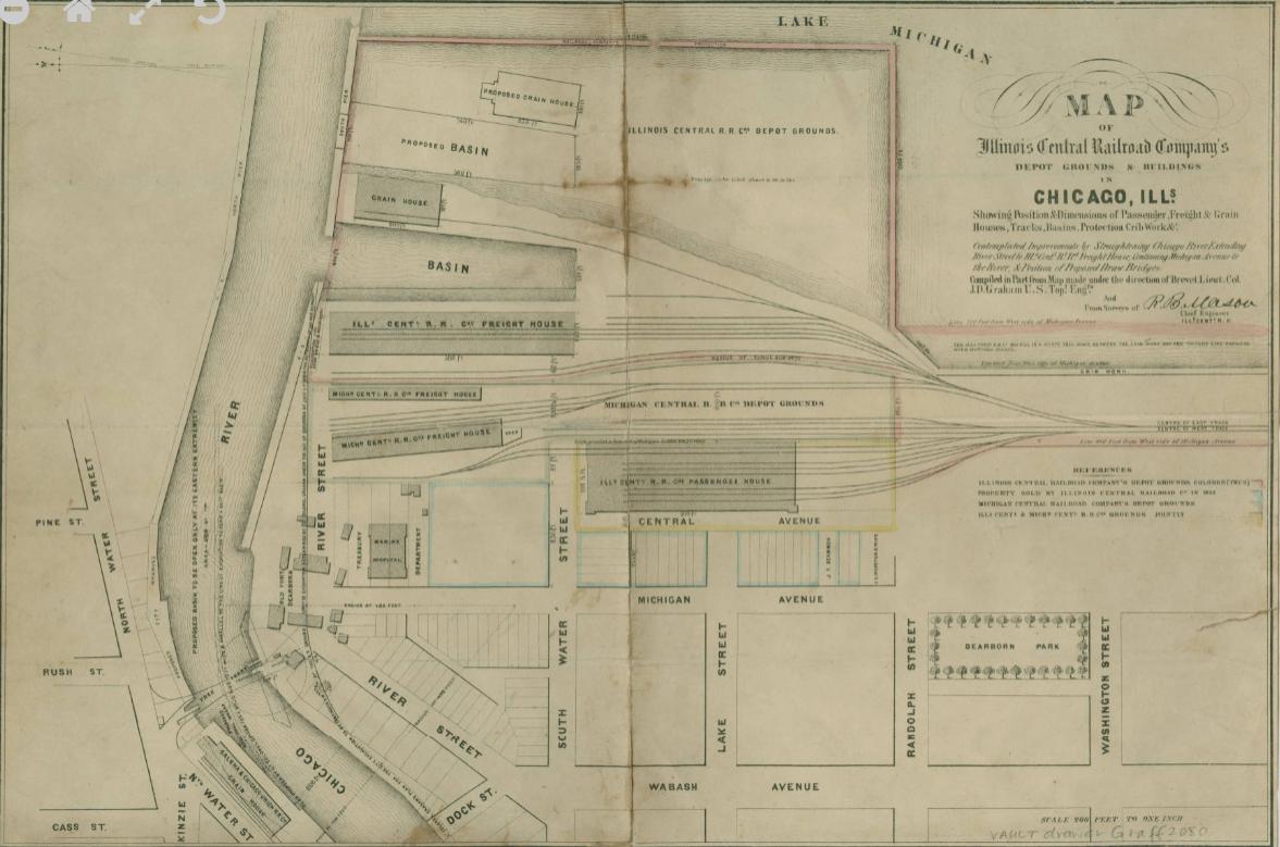
I just came across a very nice map of the South Water Street terminus of the Illinois Central Railroad in downtown Chicago The ICRR was the only one of the 6 railroads to have two downtown stations, the other one being at 12th Street on the lakefront. This map can be found on the following website
Rich
Now that is a great map! Notice the Michigan Central freight houses, something I never saw before. The current Millenium Station is pretty much on the same footprint as the passenger station on the map, though of course now covered with buildings and Millenium Park. Some or all of the waterfront track was electrified between 1926 and 1941 as part of the Suburban electrification, with steeple-cab electric locomotives, later bought by the South Shore Line.
Now if someone wants to start a thread on Chicago railroad freight houses…
I should do that. I model Dearborn Station on my layout, and it includes all 13 freight houses at the station.
Rich
One of my favorite pastimes is searching the Internet for old track diagrams around Chicago. That’s why the Sanborn Fire Insurance maps really caught my attention when they were first mentioned on this thread.
Rich
A really good map of the AT&SF Coach Yard in 1953, which incidentally also covers the approaches to Grand Central, LaSalle St and Dearborn, can be found at https://railsandtrails.com/Maps/Chicago/C&WI%201953r65%20Chicago%20Dearborn%20Station%20BE-200c.jpg .
There’s also a DjVu version if you have a reader.
One thing I noted on the map is that there was a complete wye onto the St Charles Air Line from LaSalle Street station. I don’t know if it was used to turn trains - NYC was part owner of the SCAL through MC - but Rock Island might not have had rights there.
I am getting a 404 error with that link, but here is the DjVu map of the coach yard. My understanding of the wye onto the St. Charles Air Line from LaSalle Street Station was to exchange through sleepers with railroads using other stations such as Union Station, Grand Central Station and Central Station. On the map, you can see a track coming out of the ATSF coach yard and connecting with the track leading into LaSalle Street Station.
Rich
All of the tracks heading northeast (to the right on the map) from the AT&SF coach yard head for the duck under below the IC Iowa line and16th St. tower. To go from the yard to 16th St would require backing out to 21st street (top left) and using the IC Iowa Line to 16th Street, backing onto the St Charles Air Line (top) and then choosing a leg of the wye to head or back into LaSalle.
The “Dearborn Subway” is where today’s CTA Red Line enters the State Street Subway.
I can only speak to what is shown on the map since that track was removed many years ago. However, a close up view confirms that the track led from the ATSF coach yard directly onto the Rock Island (CRIP) track which led directly into LaSalle Street Station where the NYC passenger trains arrived and departed. It is true that the ATSF coach yard was lower than the Rock Island tracks, so a grade change was obviously involved.
Rich

