In general, what is the commercial wharf height above high tide for places like Galveston, the Port of Houston, or Corpus Christi? I’m guessing 10 - 15 feet. I know it’s much lower than for ports in northern latitudes, such as Seattle. Thanks in advance for any information anyone can provide.
I took the Port of Houston boat tour back in the late 60s. My vague memories tell me that 10 feet about high tide is probably the max, possibly less. They also have those hurricanes [:(] of course…
I googled “Port of Houston” + wharf and then clicked on images. These seemed to back my suspicion that it’s probably 10 feet or little more in most cases, maybe less in some cases.
For the commercial wharf height above high tide in places like Galveston, the Port of Houston, or Corpus Christi, 10 - 15 feet is a pretty good guess.
The natural elevation of most of Galveston is 7 feet. It was raised several feet, every street, house and cathedral, in a monumental project after the 1900 hurricane, when the storm caused the greatest loss of life in any natural disaster in U. S. history. According to Galveston: A History (David G. McComb, 1986), the Corps of Engineers recommended raising the elevation of Galveston to 18 feet high at the seawall, gradually dropping one foot down every 1500 feet back from the seawall. (p.138) The seawall itself is 17 feet high. (p.139)
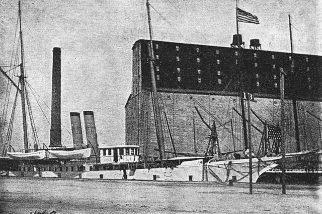
A wharf height of 10 feet or so looks like it might be consistent with this 1899 view of the Port of Galveston.
Postcards in the USGenWeb archives, apparently from the 1920s, showing ships at the Port of Galveston, suggest a wharf height of 10 or 12 feet.
(links only posted here):
http://www.usgwarchives.org/tx/galveston/postcards/harbr2.jpg
http://www.usgwarchives.org/tx/galveston/postcards/dokscn.jpg
A USGenWeb archive postcard of the Galveston mosquito fleet (shrimpboats) at pier 20 shows the docks for fishing vessels well below the level of the tracks and street.
(link only):
http://www.usgwarchives.org/tx/galveston/postcards/pier20.jpg
Another indicator of the elevation of commercial cargo wharves in Galveston is the elevation of the railroads. The rail on the 2-mile-long cause
Thanks to you both for the informative responses. Leighhant, the photos are really helpful and your layout looks great!! I’m originally from the Northwest, with more tidal action due to the latitude, and these wharves look so low to me! However, that’s how they are, and I do appreciate the help.
Just took a look at the tide tables for the Port of Galveston and for King’s Point, NY (USMMA, where I spent part of my youth.) By comparison to what I consider normal tides, the tide at Galveston barely qualifies as a ripple (1+ feet VS 8+ feet!) Hence the low quays - in New York a spring tide and a stiff wind would have waves breaking over them.
I won’t comment on the Bay of Fundy - except to say that damming it and creating a tidal power plant has been suggested…
Of course, if you combine a spring tide with a storm surge driven by hurricane-force winds, all bets are off!
Chuck (Modeling Central Japan in September, 1964 - 500 meters plus above mean sea level)
Chuck,
Very good points on why there is a range of differences in wharf height. It’s the tides.[I]
I’m sure they wish they could have a 30 wharf height on Galveston Island and in the Houston Ship Channel, it just ain’t happening. Heck, the tallest natural feature around those parts is probably some fat cat’s two story outhouse[oops]
There were something like 6,000 deaths in the great Galveston Hurricane back about 100 years ago. Lots of folks couldn’t keep their noses above water.
This thread stirred memories of taking the boat tour of the Houston Ship Channel back around 68 with the family. The Astrodome had just opened (we looked at it) and there was an associated amusement park, Astroworld, which we did visit. Took in the Houston Space Center (very cool, because we were still shooting folks into space every few months) and there was a plan to go to the moon, which actually happened IMO despite all the tales of it being staged. Come on!
Anyway, part of that trip was taking a boat tour past all the refineries, wharfs, etc while listening to a yound lady explain it for us. Since I wasn’t even a teenager yet, plenty of dork factor there. Pledged never to go back to Houston, although it was worth one visit, because it stank and went on forever, even back then.
Now Galveston, I liked it, but I liked Padre island and all those places. Even found my very own rocket down Matagordo Island, floated into the beach there from the Navy range. Took that baby home and it was pretty cool because the bit of white phosphorus still left in it would start smoking every once in awhile when I’d drag it out to play army…[wow][swg]
Thanks for the memories.[B]
We return you to the railroad prototype stuff…There were always long strings of carbon black hoppers along the highway to both Aransas Pass and Port Lavaca IIRC. I need to get me a couple of those, as I;m sure they are among the many unique cars you can run on a Houseton/Galveston layout, t