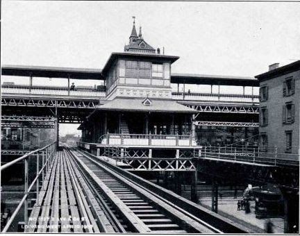
1878-1924


Looking north at 42nd St. station of 3rd Ave. El, tracks to Grand Central on the left.
1878-1924
Looking north at 42nd St. station of 3rd Ave. El, tracks to Grand Central on the left.
That thing is as ugly as sin![:O] It sure messes with the architectural beauty of GCT behind it.
As usual, these historically interesting photo postings are up to your usual high standard.
AgentKid
If those elevated railways, GCT, Park Ave., trolley cars, and a bustling crowd in the City are as ugly as sin, then I like sin or am a sinner!
Thanks, Henry, for the pictures. They truly show how people were able to reach GCT by public transport many years ago. Yes, all that is related to the spur is not as aesthetic in appearance as the station, but we can see how New Yorkers got around back then.
Johnny
The spur was the original northern terminal of the Third Avenue elevated as orginaly constructed back in the steam days. And even after the line was extended north to 129th Street and then via a different company (Suburban Rapid Transit or something like that) over the Harlem River and north to Treeemont Avenue, the branch, then worked by shuttles for the short distance, was important. The original electrification was from City Hall-Park Row to the Grand Central Depot, as it was known before construction of the existing building. The group pictures may have been taken with the inauguration of electric service. Steam oiperation north of 42nd Street continued for a few months more, with mixed operation south of 42nd Street.
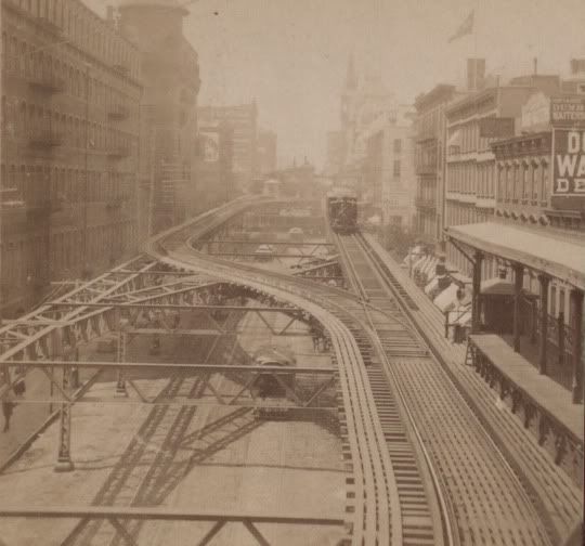
When the original subway was opened in 1904, the spur became less necessary, because the subway on Fourth Avenue could take poeple from south from Grand Central to lower Manhattan, and both the subway and the elevated were already under Interborogh Rapid Transit Co. Ownership. Opening of the Lexington Avenue subway around 1913, and the adaption of the “H” pattern for Manhattan IRT subway lines, allowed subway travel in three directions from GCT, and the spur was taken down before WWI.
The huge excavation and construction in one of the drawings is for subway construction.
In the first hotel picture, the line running into a cut and then into a tunnel south from GCD became a horsecar line, then a conduit streetcar line, and the tunnel is the now the Park Avenue Vehicular Tunnel; a gift by General Motors to the City on the occasion of the conversion of the New York and Harlem’s 4th and Madision Avenue streetcar line, then under GM ownership in 1935, to buses (M-1, M-2), the first of the “Green LInes” to be converted, the last being the 86th Street crosstown in the summer of 1936 (M-18).
Not my pics! Thank Wanswheel for sharing!!!
IN any case, they are truly terrific pictures. You deserve special thanks for the trouble for posting them. And it should be easy to come up with three of the ten answers to my question, based on one of your pictures. That leaves only seven to go.
Thanks for the favorable reviews. Now I gotta finish beating this dead horse.


Okay I’m done.
Mike
These photo’s are tremendous-the last one shows a train straight out of Bachmann’s On30 range!
Is any of this still standing today-bear in mind,I’m English and have’nt been to the States?
Steve
It is a French Christmas all over Manhatten Island: NOEL! But there are quit a few el structures in the Bronx, Queens and Brooklyn.
The els had another branch similar to that to Grand Central Depot, then Grand Central Terminal. That branch was over East 34th Street from Third Avenue to the East River 34th Street ferry to the Long Island Rail Road’s Long Island City (Queens) Terminal. It passed over the 2nd Avenue Elevated with an interchange station. It was rendered obsolute when the LIRR started running into Penn Station, and far fewer passengers used the ferry service. A reminder of its existance is in photos of the Third Avenue El’s 33rd Street station, where the pedestrian overpass connecting the uptown and downtown platforms remained in place. This branch was definitely gone by 1918.
There was also a shuttle connecting the East 129th Street station, used by both 2nd Avenue and 3rd Avenue local trains (but not rush hour expresses, just off peak 3rd Av. local expresses) to the Willis Avenue station, at ground level south of the south bronx NYNH&H yards, with both a track connection and across the platform transfer to New York Westchester and Boston trains and to the New Haven’s Harlem River Shuttle, which ran from there to New Rochelle. It was discontinued because most NYW&B and NH shuttle passengers found it more convenient to walk the three blocks distance west to the Third Avenue 133rd Street station, where all express services were avialable directly. When this shuttle was disconinued, a covered walkway was erected for these connecting passengers.
I forwarded this to my wife, and she replied “John [her first husband] used to chant, ‘Noel! Noel! we’ll have to take the subway.’”
Johnny
El structures in Manhattan: The “Manhattanville Viaduct”: No. 1 line, Broadway, portals at about 122md Street and 132nd Street. Also No. 1 line, Broadway, 200th-Dyckman Street-bridge at 215th Street. Latter also has a connecting ramp to the A -line 207th Street yard and shops.
I thought that but wasn’t sure…at any rate it is a very short segement. I think I have figured out all the surface/elevated lines that can be ridden…I have done the complete 7 line, J train, and the Astoia Line. One of my upcoming Ride With Me Henry ventures is to take a group and do Brooklyn and the Bronx. I think its a two day or two trip deal.
Brooklyn els and embankments: F between Bergan and 4th Avenue on Smith and 9th Streets, West End D on New Utrecht and 86th St and PRW from about 5th Avenue and 39th Street to Coney Island, Sea Beach near Cony Island, rest of line depressed in cut, Culver F from south of Church Avenue to Coney Island, Q and B Brighton Avenue H to Coney Island, north of Avenue H depressed in cut, Frankllin shuttle. most of the line, A on Liberty Avenue and IRT (not sure now which trains run to Flatbush Avenue and which to New Lots Avenue) east of Utica Avenue on I think Van Siclan Street (spelling), Broadway Brooklyn elevated, M and J, on eastern part of Fulton Street east of East New York, M on Myrtle Avenue north of Briadway. LIRR on Atlantic Avenue count? The Nostrand Avenue station is a typical rapid transit elevated station on the LIRR! Also, short stretch of the L, Canarsy line, East New York - Atlatnic Avenue area, then surface to Canarsie-Rockaway Avenue
Yeah, that’s about what I figured looking at photomaps vs MTA map. Franklin Ave, I am not sure of.; was told that it is a single track tunnel operation which makes it intriguing in it own right. As I said I’ve done the J train a couple times in the last few years plus the D train across the Manhatten Bridge and the A train from both Far Rockaway and Rockaway Beach Park, the Air Train from Jamaica to Howard Beach, and the LIRR. Up north, did the 7 and W trains. Some Coney Island I did as a kid, but doesn’t count now. So have to pick up the rest and do the Bronx hopefully this summer or fall.
Sin away Henry!! [:D]
Thx IGN
The IRT Nostrand Av line to Flatbush Av is underground(if I remember correctly)
Also the Brighton Line is on an embankment from south of Av H. to 12th and Neptune Av. Then it is on an elevated structure into Stillwell Av.
One last comment. The Canarsie line had the last grade crossing of the NYCTA.
Thx IGN
The Franklin Av Shuttle is a double track operation as I remember it from the last time I saw it in the 1980’s . Then NYCTA used 2 train sets and spring switches at both Prospect Park and the Franklin Av ends of the line. One other comment I think the tunnel entrance to Prospect Park is where the BRT suffered a disasterous wreck that killed a score of people, and put the company into bankrupcy. If I remember correctly the station was originally called Malone St, as was the wreck. The accident was so bad that the street name was changed as was the name of the station.
Thx IGN