I added this one map as it it the continueation map oftheColeman branch. Also the map holds the FLIGHT 93 crash site as well. My phone number is listed on my web page if you care to get in touch with me. I would like very much to meet with you.
Thats what I mean. There is so much in aids to locate and discover what it all means. Maps, aerial photos, photographs actual South Penn survey maps work sites just so much. I can’t wonder off the South Penn, It might never get done but it is a great time discovering everything about it. Remember I have 3,700 documents psted on the CD’s. And these are only choice items I chose to put on the Cd. Imgine what I do have not put on there. have a whole kitchen cabenet full of 1.4 floppys filled with photos. Quarries, cuts, fills, houses, creek turns, barns, letters, drawings culverts, stone work still laying in the woods. All showing what I have discovered. Sort of like discovering the tombs of the egyptians kings. All in my own back yard. Less then an hour from my home.
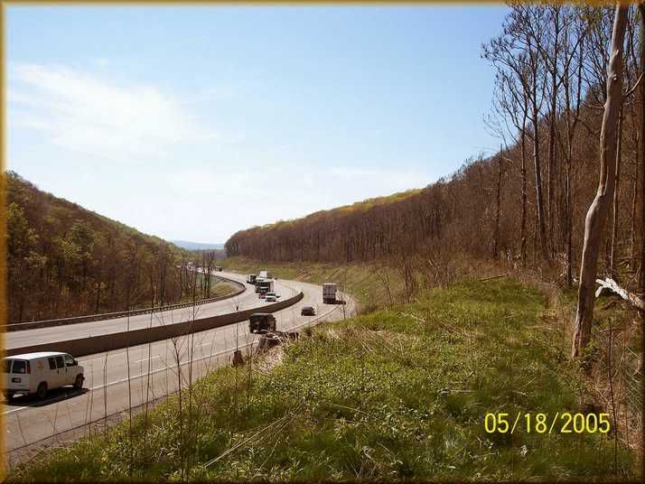
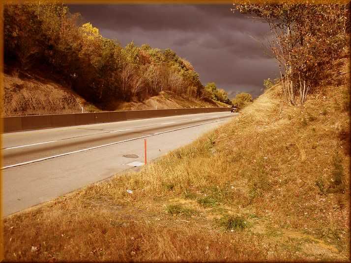
This photo looks innocent enough right? Well you might want to think twice about that view your looking at right now. Can you see the South Penn grade in this picture?
This site is located exactly at mile post 98.5 This is on the west side of the Laurel Hill Mountain and would have been a 2% grade as stated by the 1884 railroad report found on my web page at http://www.southpennrailroad.com click on the 1884 report button. Beneath this grade is a stone culvert passing beneath this grade that looks like a shelf to hold back rolling debris. Its not. The hillside to the right would produce nothing that could harm the highway. This is the South Penn grade I am on looking west towards Donegal.
Imagine the turnpike and the railroad operating together here. All the cameras being set off as the cars go by. By the way I am taking this from my 60 MPH moving S-10 pick up.
Thanks for all the last post’s data Russ…I will dig into them. And the bonus of Coleman branch…Have been to Flt. 93 sight…Know fellows that were some of the first responders from Stoystown Fire Dept…By the way, that’s my home town. Just 450 pop. I’ll check all the data you note…Thanks. Numbers too.
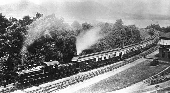
I’m astonished as to how much has been contributed regarding the Rockville Bridge.
The earliest? Here’s a nineteenth century view of the PRR’s Pennsylvania Limited coming off the Rockville Bridge. As the PRR’s premier train, it was their first to have all vestibule Pullman cars.
Thats a great old photo. I want to explore more of that site when I go down in June. I really want the one inthe beginning of this forum. I just want to know how to get to the top of that mountain overlook.
It seems that we got a little off track but if you read the chain from the beginning you will see where it lead. It really does have its feet in the South Penn. I am very interested in the competition of this Pa. Line with that of the SPRR.
So much to look at Russ…{and by the way I have an S-10 pickup too…an Xtreme. I have {on the computer here from some time ago, the maps showing the PW&S over the Laurel Hill but have not seen from Quemahoning tunnel down to Somerset before…Your views show it and easier now to understand as it makes it’s way to connect to the B&O, etc…
Like the way the SP shows up on the top. maps…Great bunch of stuff…
Understand about getting lost on the maps…Thanks.
More later…
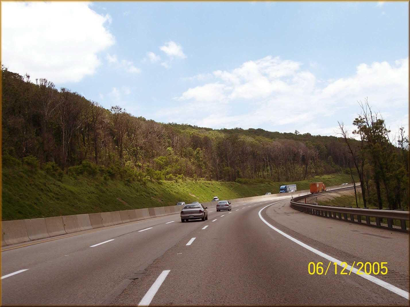
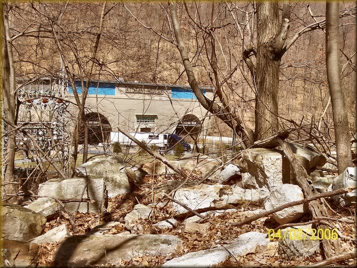
Even a super highway or one like it didn’t seem to totally destroy all the traces of the remains of the South Penn railroad. At the crssing of highway 219 passing beneath the South Penn grade just north of Somerset and east of the Walmart store.
Look just above this auto traveling north on highway 219. You can see the shape of the railroad grade embedded in the hillside just below the evergreen trees.
This is part of my CD And some great reading about getting men to the Fort Littleton, Fulton County area…
“B. Gordon” wrote:
George Regi"s
Laborors on the Vanderbilt Railroad
One spring afternoon in 1883 George Regi, with 399 Italians, left the train in Ft. Loudon, Franklin County. Regi asked how he was to get his men over the Cove Mountain, learning that not enough vehicles could not be assembeled in a week, he decided to lead the way on foot. It was 8 miles over the tortous dusty road to McConnellsburg and the grade 12 to 14 per cent in some places. Each of the Italians had one piece of heavy luggage, and their thirst upon reaching McConnellsburg can be imagined. Consequently, they decended upon the first hotel in their path and depleted the bar’s content in no time at all. Regi then lead the 4oo to the Fulton House which had been catering to thirsty travelers since 1776. The supply at the old stone hotel lasted barely longer then the first stop. Beer, liquors, wine–they disappeared in no time at all down the parched throats of the Italians. The propritor said he would order a supply from Chambersburg but that meant a five day delay. So the laborers moved on to the last saloon in town, where the supply was consumed in no time. Regi then took his men to a camp in the hills near Hustontown. McConnellsburg was completely dry for the first time in existence. Regi spoke 7 languages and had been in the United States for 4-5 years. He was the first labor contractor to bring Italians to this country, and the Vanderbilt interests gave him the contract for supplying labor for the entire job. He had 2300 men on the job when orders came to stop work. His men were paid $1.25 a day for the ten hours work and he opened 31 commissaries. As this was the first time Italian labor was used in Pennsylvania, Regi’s men attracted considerable attention. Ten or fifteen years later Italian’s were found on all construction jobs in the east and the army
Well now that we see just how the railroad crews got over the mountains near Fort Littleton, Lets explore some of their work that still lays in the woods today along the Pennsylvania Turnpike there as well.
Above: A completed fill hidden in the mountains south of Fort Littleton.This can be found on Microsoftterraserver.com
Closer to the Pennsylvania Turnpike is this view of the turnpike crossing from left (west) to right (east) over the South Pennsylvania Railroad. Mile post 182.4 exact marker. The dark cut on the opposite side of the turnpike is the South Penn grade crossing to the point where the red turnpike marker is seen just to my right.
These two names are best known for the area between the Twin Tunnels. Those who don’t know this area, this is the valley between the Blue and Kittatinny Mountains (mile post 198.0) just west of Harrisburg, Pa. This view shows and interesting South Penn work site found by me reading up on some old 1935 newspaper articles writtn by David Fensler. He mentioned that some of the stones which were to be used for the railroad were still seen in this valley. I got permission to explore this valley and here is what I found just to the south of the eastbound lanes along the turnpike. WARNING!!! SNAKES ABOUND PLENTY HERE. also it is llegal to explore this area or almost anywhere alongthe turnpike. The State Police frown upon you leaving your vehicle to explore on their property. $375.00 fine for doing so.
The tunnel farthest away from me is the railroad tunnel.
Finding the South Penn railroad is one thing in areas where the grade is actually built showing tangible work sites to view. Examples are as we just saw on the previous posts. However locating exactly where it was to be built in areas that not a bit of dirt was turned by the railroad is a whole new search. Difficult. Well not if you have the maps. It was really simple as the surveyors did the work some 120 years ago. But knowing what to look for along the turnpike is the real mystery.
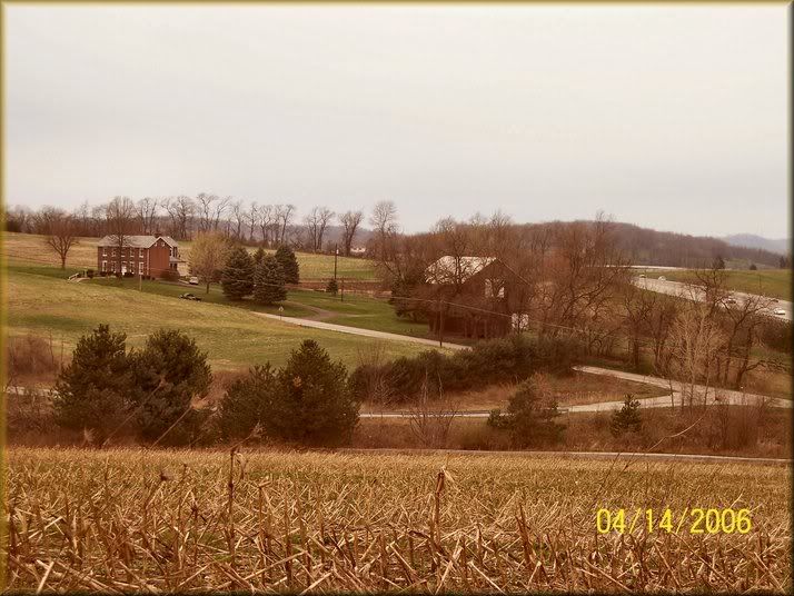
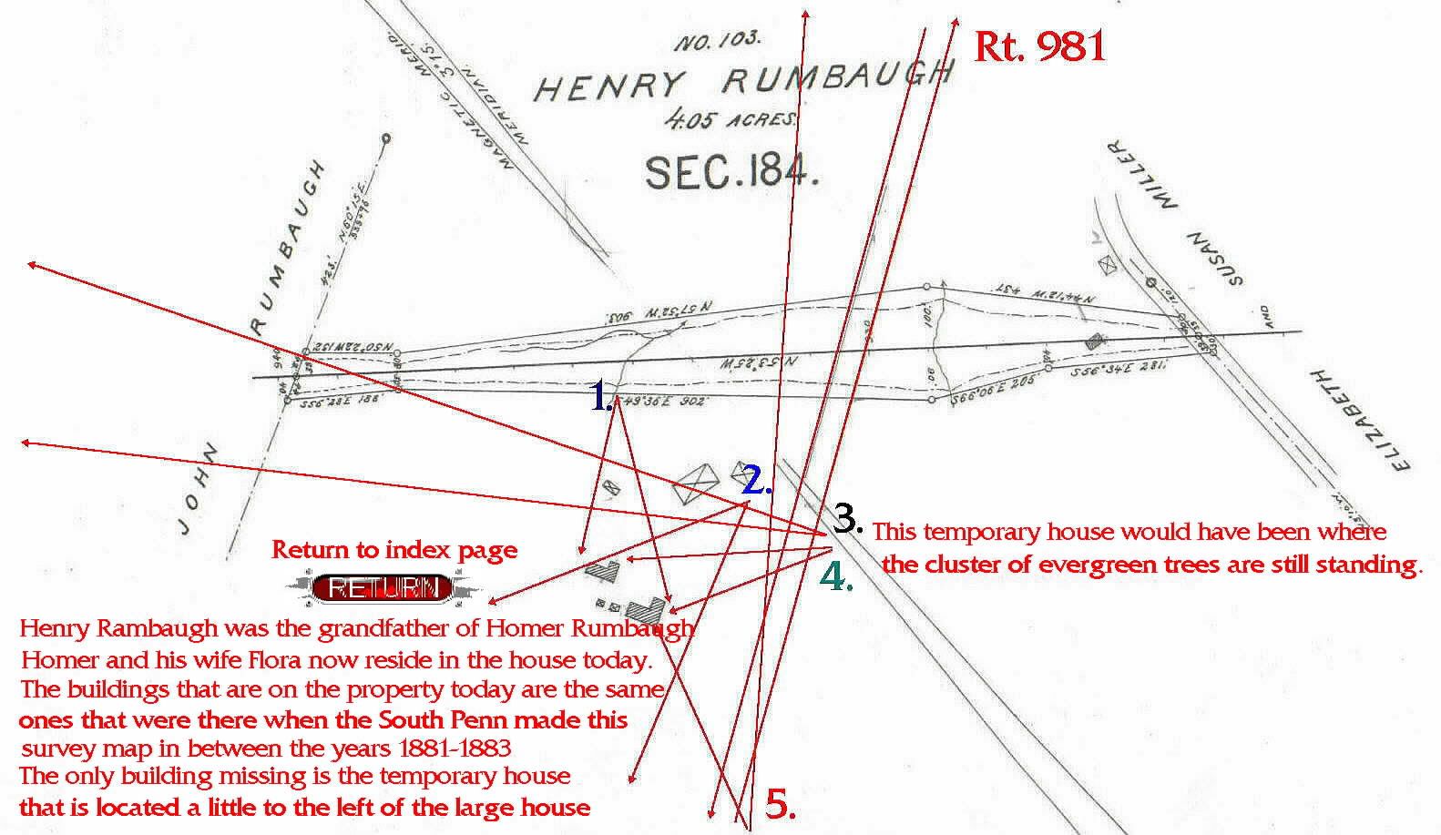
This paticular site is the Rumbaugh proeprty located in Mt. Pleasant twp. Westmoreland County. Now remember no work was done west of Donegal which is the 90 mile post and we are now located on the planes west of the Chestnut Ridge Mountain at mile post 80.6. As I did in a previous posted map, I pieced together the individual plat maps making one long one and included on that map long map is this proepty.
I include the photo and the map showing that the location where the turnpike is was indeed built on the exact location where the railroad would have built on. According to the 1884 report, this site is where the South Penn was going to split off and one branch would travel north to the Frick coke works east of Latrobe (Saxman works) and another southward to the Frick coke works in the Mount Pleasant area in the Westmoreland County area noted for its thousands of coke overns which were at the time being only serviced by the Pennsylvania Railroad. It was hoped that the new South Penn would take some or most of that business from the Pennsy and get it onto Vanderbilt’s NYC lines.
…Speaking of snakes Russ, back several pages I note the picture of a person…{you…?}, at the opening of a tunnel with lots of ice columns and wearing high leather shoes and I figured a good foot wear and leg protection from the rattlers all over the mountainous area…Especially in warm weather.
Additional pictures in last posts great…!
You had asked in a post last evening if I had ever seen any remains of construction of SP just west of Laurel…and I believe I must answer yes, but sometimes the memory starts to run together since I only get to do it roughly twice a year or so…
No that is not me, it is a Pennsylvania state trooper who worked no the turnpike for 18 years and was unaware of the tunnel he is seeing at that time. He was quit excited about it. Yes I try to wear walking boots, however I sometimes get a few hours off work and head straight up to see the sites and don’t get a chance to get them from home. So often its just tennis shoes.
I figure that if you have seen so much from afar, that you must have made some effort to just see them. I decided that to just see them was not enough. I figured I might as well make the work they did a focal point and a subject. After all trains never ran on it so I had to find a subject to picup and show. So the culverts and other works became my trains. Not many people look at the actual work but focus on the trains. The South Penn was a diffrent subject and neded to be looked at diffrently. If shown properly it too could be interesting. I’ve seen many photos of trains, but color schems can only be done so many times. I do say that at times, I do see trains at a certain spot that I know would make great shots butjust stay away from them.