I’m getting ready for the next stage of my layout (a 10 x 6 space for HO scale), and I believe that will be forming the general landscape of the layout (hills, rivers, etc.). I have a track plan in mind, and a general idea of the topography I want, but its time to start getting some details.
So before I start, I’m looking for some advice and tips on how folks go about taking ideas and making them into reality? How do you make sure the topography you build into your layout meshes with your track plan? Do you mark up the space?
The scenery depends on what “look” you wish to achieve, the modelled location of your layout, and how much room does your track plan allow you to “play” withh, not only scenery but also industries. Which ideally should be factored into your “build plan.”
Off the cuff, make sure that you have enough clearance for your trains to run without snagging the scenery, this also applies to trackside buildings.
One thing I’ve noticed is because of lack of room, changes in scenery elevation are more vertical than in reality, that is unless your modelled area is the Rockies, or the Grand Canyon.
I’m not sure if the “New Forums” search function works better than it did on the “old forum” but there is enough good information there to thoroughly confuse you!
I think my track plan decently accounts for all those things, but its the execution I’m nervous about. I’m thinking of just taking a pencil and tracing it all out on the table.
While I’m a big believer in “do it once, do it right,” my day job demands it; it doesn’t necessarily apply to my model railroading activities, it is supposed to be a relaxing hobby, right?
Drawing on the table and even going to the length of making cardboard mock ups are perfectly legitimate means of obtaining the end.
As you’ve taken into account clearances, etc, don’t be nervous, dive in, Have Fun, and if the worst comes to the worst and you don’t like your result, just rip it up, and start again! You won’t be the first, or the last to do so!
To look for ideas, it helps to know whether you have a particular geography in mind. Perhaps take a few walks through a forest or anywhere even away from a city/suburb to get ideas. You also can look at slideshows to see ideas. What I learned in doing similar is nothing in nature is “perfect.”
You also might benefit from creating footprints of where you want to add structures. This way you avoid putting in scenery where you want a building. There’s also noting wrong with having areas without any trees or bushes, but the frequency of these spaces greatly depend on the geography you plan to model…
I have roughly the same sized layout. I’m not very disciplined or very scientific about anything I do (although I did make sure my trackwork is faultless before moving on, otherwise what’s the point?). Accordingly, my scenery happens pretty much organically as I work on a given area. And I am not averse to ripping out first attempts. I am currently redoing a hillside that was too close to the inside of a curve for me to add rock faces to it without interfering with the track, and it was also made from plaster sheets, which for me is hard to stick trees into without them tilting over. I’m using layers of pink insulating foam to build a new hill.
I have loose ideas about what I want but things often don’t work out the way I envisioned it and something better emerges. I need some of that serendipity in my hobby life. It’s not a way I would necessarily recommend for anyone else, and if you can plan well, more power to you.
An example that I’m proud of is this promontory that resulted from my very constrained track plan. I didn’t know what I was going to do with it until I started putting foam in place, and it started to look like a place just outside of town where a prominent citizen might have built a nice house.
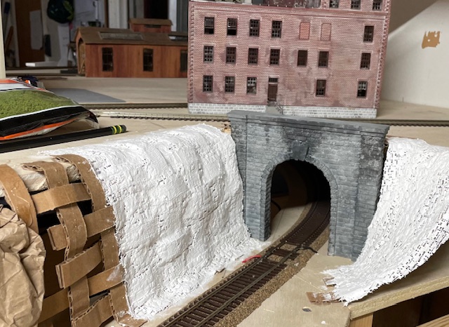
Here’s an example of a do-over on my layout. I started scenicking around this tunnel entrance but I didn’t like the result I got with plaster sheets over lattice.
Matt, I think that your approach worked just fine. As I looked at the first photo, I thought that the approach was right. When I looked at the second photo, I thought maybe not. But that third photo is a winner. You did good.
I have a different challenge than those of you who have highly scenic layouts. First of all, my layout is perfectly flat since it is based upon Chicago passenger stations and the surrounding areas. The only exception is a deep area containing the south branch of the Chicago River. This is a highly industrial area, so my challenge is to add some ground cover and trees without making it look like a wooded area.
So what I do first is model the area, space the structures, ballast the track and, lastly, add the landscaping, trees and ground over. Here are a few examples.
Thank you all, these are wonderful replies and exactly what I’m looking for.
@kasskaboose that is good advice. My modeling is going to be extremely loosely based on where I grew up and where my fiance grew up, so I think I have some good ideas there.
@crossthedog that’s a good tidbit about plaster vs. foam. I had been waffling but leaning towards foam. By the way, your promontory looks incredible! I love it. The cliff face you did all by hand? It looks amazing too. I’d love to hear more about your process.
Now, that’s a darned good question, and I could not remember, so I went back and looked at progress photos. The answer is Yes, I did do the river after placing the structures and track, although I had planned the whole scene beforehand. In the photo that follows, you can see the progression of my work on this area where I was testing different channel rocks.
I just start right at this point for a most areas - I have a general idea and just start adding plaster cloth and scenery until it looks about right.
I am modeling specific areas, so I work from photos a lot, but with one exception I don’t try to match specifics - just the general feel of the area. For example, here’s an area near Hudson WY:
The Wind River Canyon area is the exception. I’m trying to much more accurately represent what’s actually there. Here are two tunnels in the real canyon:
I think folks above have covered things well. Before diving in, lay out buildings, roads, and other key scenes/details to get a sense of how it will all fit together. This will likely change as you start building terrain. If you have the models, great, but mockups or even just footprints cut out from paper can be super helpful. Also, do a bit of research on the area you are modeling through Google Earth, Street View, and any photos you can get your hands on. Below are a few photos of the town of Paonia on my layout. They give an idea of how things came together.
@Pruitt great job, I think it looks great. It looks like similar to other folks here, you laid track down first and then modeled landscaping around it?
@Casey_Dowling that’s very impressive. What size is that portion of your layout?
One thing I could add regarding topography is to think like those crazy railroad civil engineers did and make the amount of materials removed from cuts roughly match the amount of nearby needed fill. Moving earth is expensive, so the railroads try to minimize that to save on expense. I had that in mind when I built this section of the layout.