Reading some articles on small cities that have modern light rail (or at least restored trolleys), I got to wondering what the SMALLEST city in the US that has a modern light rail system is. And what’s the smallest that has a restored trolley line?
Kenosha Wisconsin would be my guess. Any trolley fan would enjoy the PCC cars. The Kenosha website is superb with excellent photos. Kenosha is served by Metra from Chicago and is reasonably close to I-94.I believe the exit is state highway 50.
Surely Santa Clara, California, is smaller than Buffalo, New York? Here’s from Wikipedia re Santa Clara: “As of the census of 2000[4], there were 102,361 people, 38,526 households, and 24,117 families residing in the city.”
There are several modern LRV lines going in different directions there. At one point, according to their site, old-time trolleys were mixed in at 60-minute headways in the central area; IIRC it was just after Thanksgiving. I do not think that is an ongoing thing.
Are we basing city size on location of terminal, as opposed to communities that LRT lines travel thought? Because the three Santa Clara lines serve a slew of Silicon Valley suburbs (ah, sweet alliteration!), and perhaps one or more of them is smaller than 100,000 in population. - a.s.
Thanks for the information! I’m only asking because I’m trying (for a project related to my schooling) to figure out whether Worcester, MA, is large enough to support a light rail system. It has a population of about 176,000, the second largest city in New England after Boston.
With the MBTA Fraingham/Worcester line terminating at Union Station, and Amtrak’s Lake Shore Limited also serving the station, the light rail system could serve as a feeder line for those services. Perhaps it might also serve the underutilized Worcester Airport (7000 foot runway and $15.7 million terminal, and there’s one commercial airline right now!) to relive congestion at Boston Logan. And people are more likely to take light rail to get places than a bus, which is the current mass transit system.
For those who are wondering about this schooling project, the First Lego League robotics competition (which I’m to old for, but I’m a mentor for a team) has a transportation theme this year. The objective of your reserch project is to get involved with your community and solve a problem related to your local area. I’m just doing a little work beforehand… Plus since I’m going to send the completed study to the city of Worcester, if they actually use it and build a light rail line, that would be really neat!
Do you think a light rail line is feasable? I’m checking out Google Maps for some possible routes, seperated into different construction phases. Being affordable isn’t too big of a deal; Worcester won’t be able to afford it themselves, but hopefully they can snag some of that stimulus money…
It sounds like you’ve given some thought to traffic sources. Don’t forget such sources along the line as well - shopping, night spots, etc. Consider too “park and ride” arrangements that will allow people to park in a convenient, safe location and take the light rail to their destination.
Speaking of shopping - I just took a look at Worcester - that “outlet” mall could be a draw, along with what appears to be an arena. Again - people can park outside the city and take the light rail in…
“Location”, in the sense of the routes as tree68 mentions, on a broad or general scale between likely traffic sources and uses, in view of the geography, major obstacles and opportunities, areas already well-served by competing modes, etc.;
“Alignment”, as in the details of the location, esp. for R-O-W: Can you use streets ? Even if you can, do you want to ? Any of it in a hgihway median ? If not, then where instead ? Is there a strip from 20 ft. wide (rock bottom minimum for single track) to 50 ft. wide the entire length of where you want to go ? Good places for stations ? Terminals / Layovers ? Passing sidings (if single track) ? Substations for power supplies ? Proximity to high-voltage lines to supply same ? Any big water bodies, roads, railroad lines, hills, ravines, or other obstacles to cross that would require expensive bridges (or tunnels), or another way around ? Anything else ? And so on.
Look at other similar systems to see how they’ve dealt with similar challenges. Since you’re close to Boston, look at how their lines are laid out as an example of acceptable curves and grades - it’s an historic built-up urban area, so I’m sure not all routes and locations are ideal - and so is your area. Some others that I’m personally familiar with that could serve as examples for you are: NJ Transit’s River Line from Camden to Trenton (also the line in the Newark area - Hudson [?] Line); Philadelphia’s SEPTA system in the western suburbs - the Route 101 and 102 trolley lines to Media and Sharon Hill, and the Route 100 High-Speed Line from the 69th St. Terminal to Norristown - see: http://www.septa.org/maps.html ; and the Portland, Oregon Tri-Met MAX Light Rail syste
Well, I haven’t given much thought to running them in public roads, since I only looked at the ones with the center medians. And they’d need to connect to Worcester Union Station, since one big selling point is the system as a feeder to the commuter rail line to Boston.
Larry: Yes, my plan will serve both the stadium (was branded for some company, but I don’t remember what and Google Maps isn’t up to date) and the Greendale Mall. See below.
For the first phase of service, I’ve put together the beginnings of a presentation for running the tracks parallel (never physically connecting, since that would require use of FRA compliant equipment) to the CSX/Pan Am line to Ayer, MA, which is actually owned by the Providence & Worcester Railroad till Barbers, where the planned line would end. Here’s the route, complete with maps of the planned stations. EDIT: Ignore the HTML code… Just a byproduct of pasting text from MS Word…
How much bus service is provided now on the corridor you are proposing? If reasonably well used, does it encounter traffic delays? Have you places for commuter parking? Will existing or new bus lines serve as feeders to light rail?
Teacher? The forum ate my homework… Actually I bumped the back button and deleted my post…[banghead]
To summerize the post I had written:
The current bus service is about the same as a typical light rail line would be, except with more stops and a bit slower. I don’t know how well ridden it is, but I know it isn’t just a ghost bus.
There is plenty of parking at all stations except the Phase Two stations. New Bond Street and Quinsigamond College have none or close to that. They’ll be served by the bus feeder lines. Here’s a map of the basic feeder services:
I was actually thinking that the line would work better as a commuter rail line on the existing track (since it would be FRA compliant, no new track is needed except a couple passing sidings) between Worcester and Ayer. Same route, just extending a lot longer. Two push pull trainsets would have a two hour round trip, so an hour between trains at the two endpoints. Stations would be some of the ones I proposed for light rail, plus new ones extending to Ayer:
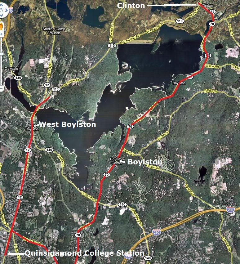
Worcester Union
WPI Biosciences Lab
Quinsigamond College (served by bus feeder lines)
West Boylston
Clinton (midway on the line, trains will pass here on a new siding)
Bolton (Route 117 park-and-ride station)
Ayer
Markets served by the service would be:
Passengers traveling between any station on the Framingham/Worcester and Fitchburg (at Ayer) lines.
Commuters to Worcester’s growing Biosciences (Worcester is on the leading edge of stem cell research) industry from points on the Fitchburg line and the I-190 corridor.
Commuters to Worcester’s Medical industry, one of the largest in New England. Also on the Fitchburg line and I-190 corridor.
Commuters to the Devens business area, which is quickly growing.
I think commuter rail is more viable (and easier), so therefore a
To respond to your inquiry regarding the feasibility of commuter rail instead of the previous “new build” light rail proposal, more info is needed, I think… Such as (and displaying my ignorance of details of the area, but anyway):
Which “legacy” RR built and operated the track back in the day ?
Whose track is it now - owner ? Lessee (tenant) or designated operator ?
Any passenger on it now - if so, who & how often ?
Any freight on it now - if so, who & how often ?
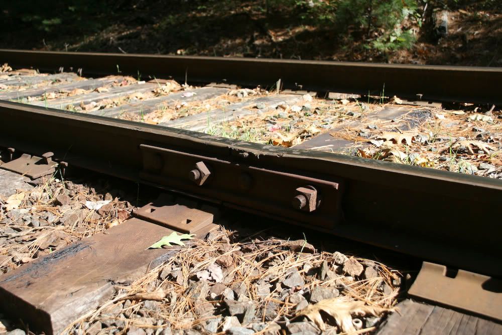
What condition is the track in - just generally and superficially, as seen from grade crossings and public access points, not from a walking inspection - good, fair, poor, etc. ?
Well, I haven’t given much thought to running them in public roads, since I only looked at the ones with the center medians. And they’d need to connect to Worcester Union Station, since one big selling point is the system as a feeder to the commuter rail line to Boston.
Larry: Yes, my plan will serve both the stadium (was branded for some company, but I don’t remember what and Google Maps isn’t up to date) and the Greendale Mall. See below.
For the first phase of service, I’ve put together the beginnings of a presentation for running the tracks parallel (never physically connecting, since that would require use of FRA compliant equipment) to the CSX/Pan Am line to Ayer, MA, which is actually owned by the Providence & Worcester Railroad till Barbers, where the planned line would end. Here’s the route, complete with maps of the planned stations. EDIT: Ignore the HTML code… Just a byproduct of pasting text from MS Word…
From Worcester Union Station, built on unused platform on the north leg of station, running on existing track purchased from P&W/CSX. P&W and CSX trains run on the parallel tracks, physically separated with track cut off
Trolley buses? Those aren’t as cool as “real” trolleys… [:-^]
Paul: I would be happy to give some more information! We’ll split the track up into two categories: Worcester-Barbers and Barbers-Ayer.
Worcester-Barbers
The track was originally New Haven or Boston & Maine, I’m not sure. Nowadays it is owned by the Providence & Worcester Railroad (very railfan friendly, a great “local” railroad). CSX has trackage rights from Worcester Union Station to Barbers (a couple miles north on the line, part of Worcester). There is no passenger traffic. P&W runs some freight trains on it, all “as needed” but less than three per day, I think. CSX runs one train in each direction, Q426 and Q427. The track is in good condition, most likely heavier jointed rail.
Barbers-Ayer
This was originally B&M track, and is now owned and operated by Pan Am Railways (formerly Guilford). CSX Q426 and Q427 also run on it after the Barbers crew change, as SEAY (Selkirk, NY - Ayer, MA) and AYSE (Ayer, MA - Selkirk, NY) respectively. Track is heavier jointed rail, mostly in fair condition, but there are some low joints.
Update: The Boston Surface Railroad which will have introductory service from Providence to Worcester starting in 2021 should eventually serve the route from Worcester to Ayer, continuing on to Nashua, NH.