…A photo in a book I have has a view of the SP RR pylons appearing to be constructed of large shaped stone and capped with a large concrete top. In the background {on the left}, is a stone arch bridge all the way across the Susquehanna River and a city or town is visible on the other side of the river. Photo by William M. Metzger and in my “South Pennsylvania Railroad” book by Walter F. Walton. I don’t know if that is a pic of the Rockville bridge or not…There is an island near the center of that bridge. Also don’t know which side of the river the photo was taken.
Can you get a uploaded photo of this pic?
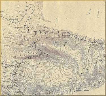
Presently I am uploading a pic of the proposed South Penns Horse Shoe Curve survey map which was to be built just west of the Laurel Hill Mountain and north of the Pennsylvania Turnpike. A section of the tunnel will be includeed in the map to give local. This was a section located in between actual work sites but this site was not begun.
http://i33.photobucket.com/albums/d64/spennrr18811885/oldmapm.jpg
Yes, picture does come up when clicked but is not much larger…
No the picture you have in the Walton Book you described is the one I am interested in viewing. Can you send that photo to me? And if you want the picture larger, I supose I could send it to you via e-mail if you want it. I send them via photo bucket and they must shrink it down. Ask and I will be happy to provide what you want.
Oh, sorry…misunderstood. Will see if we can transmit via scanner of the walton photo. It may be a bit later and might even be tomorrow, but I’ll see what we can do…You don’t need to bother on the map pic…I can see it ok…but thanks.
You are describing Harrisburg not Marysville.
Looking north in this photo, you see the ex-Reading
RR bridge, then the Cumberland Valley RR bridge,
the piers of the Market Street bridge, and finally
the piers of the Walnut Street bridge.
http://www.railpictures.net/viewphoto.php?id=140218
The South Penn RR bridge was between the much
later ex-Reading bridge and the CV RR bridge.
Looking east from Lemoyne, you see here the capped stone
on one of the surviving piers of the South Penn RR bridge.
http://www.railpictures.net/viewphoto.php?id=138889
Dave
http://i33.photobucket.com/albums/d64/spennrr18811885/SPRRPhilaReadingConnection.jpg
Here is a 1883 South Penn survey map of the South Penn entering Harrisburgh via the Reading line and temporarily using the Lebonon Valley station just to the left or north of the Pennsylvania Railroad station and then exiting across the proposed South Penn new Susquehanna River bridge. bridge piers still stading.
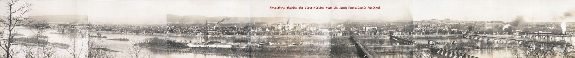
http://i33.photobucket.com/albums/d64/spennrr18811885/panharrisburg.jpg
Here is a panaramic view of Harrisburg Circa 1906 and shows everythng from the Rockville bridge (left side of photo) to the Reading Bridge to the right. Look close at the base of the Reading for all the piers that are gone today. The ones still standing in the river today are not in this photo, they are outside the photo.
http://i33.photobucket.com/albums/d64/spennrr18811885/WaltonFarmSurvey.jpg
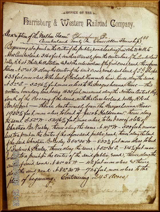
The South Penn was only going to use the Reading terminal until they could get their yards and terminal buildings bult on the west shore of the Susquehanna River. Here is the survey/Deed for the property across the river. If you follow the main road runing north and south from New Cumberland to Market Street, there are several names marked on this deed that are street names today in that area.
You describe the Rockville Bridge as being the one of the left in the pic…yet the pic appears to be in downtown Harrisburg…The Rockville Bridge should be further North, away from downtown I would think…
Modelcar
I got your mail.
Thanks, Had I known what photo you were sending and that I already saw it, I would have not asked but I appreciate the sending of that photo from the William Shanks book, Vanderbilt’s Folly. Of course it seems to have been in the Walton book as well. I have my own color shot of that view as well. I will be replacing it when I get back to Harrisburg this June. As I said earlier I am replacing all my shots with a 6.1 mega pixal camera from my Kodak camera.
Thanks a lot anyway once more.
dwil89
Send me your e-mail and I will send the larger view of it. But the Rockville Bridge is indeed there. The large view is where you see it best. A section of it is just to the right of the second largest set of tree brances on the left side of the photo. Remember this is panaramic shot, not actual scale.
http://i33.photobucket.com/albums/d64/spennrr18811885/kimberlyrunhill.jpg
Here is a South Penn shot looking north from Highway 31 in Somerset County just east at the 115.0 mile post along the Pennsylvania Turnpike. Look above the truck for the tall railroad grade.
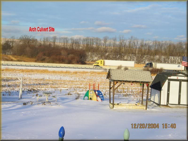
What a rail fan shot that would be don’t you think?
It’s tough to see, Dave, but you can just
make out the Rockville Bridge.
Dave
Russ…10-4, you are welcome for photo…Boy your last photo posted at location Rt. 31, Somerset is my home stomping grounds. Currently, there should be some power producing wind mills near by and behind the camera up on the rise. I know right where you are for that shot. Right west of that location we find a bunch of cuts and fills near the State Hospital and then a little farther along {west}, it crosses highway 281 with a massive cut on the east side of the road and then a large fill on west side of the road…with a stone and brick tunnel to allow the S&C branch of CSX {formally B&O}, to run under it as it’s route heads to Johnstown. Then the SP swings around to the left and crosses Rt. 985 and starts it’s way to head towards climbing Laurel Hill…I’m sure you must have tramped over most of the above I mention…Quite a bit of the ROW can be seen in that area…
…Must head for the TV…Our Pacer’s are ready to start the 2nd game of their NBA playoffs…
Great Shot [:D]
Glad to bring memories upon you. I love this area as well. A new Walmart is now along the South pen norht of Somerset. That main highway traveling north out of Somerset to Jennerstown is now 601. Have you walked all of the right of ways exploring it? Or just looked at it from afar.
http://i33.photobucket.com/albums/d64/spennrr18811885/daklemanbA.jpg
By the way the dirt crossing the center of the photo is the South Penn grade curving south to circle the hill located behind the photographer. The turnpike got rid of this grade and went right through where the photographer is standing.
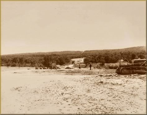
http://i33.photobucket.com/albums/d64/spennrr18811885/allgtunnelw.jpg
A rare photo of the west portal of the Allegeny Mountain Tunnel. Only the tunnel you see is actually the South Pennsylvania rairload tunnel being preped for a wall cover up. The railroad tunnel is still there but hidden behind this wall seen in the photo on the bottom . The wall in the modern photo seen on the north or west bound turnpike tunnel built by the turnpike is where the railroad tunnel is still located hidden from prying travelers eyes. However, the east portal is completly open. By the way it is a $375.00 fine for being in these areas. I just had to let you know.
HEY!
If your not interested in this Please let me know so that I can do other things but of course if this is interesting or maybe you think it should be placed some where else also please let me know.
I never did want to hijack this thread. I just figured the South Penn was supose to be in the Rockville Bridge area and figured intrest was good so I just went on.
Thanks
Russ