I mentioned yesterday that it was fine to add this information to the thread…
Thanks!
This is interesting article Read it close
Amazingly your looking across the road from your house at the useless piece of property saying to yourself just how much an isore it was to you. Then the turnpike comes along and then says you are the real owner and that you will be given so much for it so that they could build the turnpike on it. because it was originally the South Penn grade.
Then there is the farmer who thinks they owned it and were told they have to give it up because it wasn’t theirs anyway. Maybe they were payng taxes on it all those years. HUMMMM!
Even to this day sections of property are made useless due to the turnpike cutting off farmers from getting to the field across the turnpike from thir farm buildings. I know of many a sites like this in my research. One located just to the east of the 819 highway crossing in Westmoreland County at the mile post 79.0.
The right of way of the South Penn is really interesting and has been for years.
http://i33.photobucket.com/albums/d64/spennrr18811885/trpkrightofway.jpg
Russ…I have been on the ground at some of the places in the Somerset area. Understand the west face of Allegheny does hide the original RR tunnel over north of original Turnpike tunnel. Dave, if you want this part of post to stop just give us a shout…and Russ it’s all interesting to me…How about other fans…
No, keep posting away…it’a all interesting, and never would have come to light here if the topic of the Rockville Bridge was not brought up to begin with…I am learning alot more about the South Penn Railroad and its significance to the construction of the PA Turnpike.
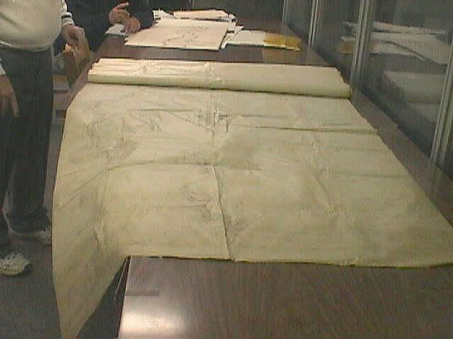
For the past several years I have visited the State Archives to get what ever I can on the subject of the South Penn. This shot shows one of the largest South Penn survey maps that I now own on CD and is not completly opened for viewing. This one is actually a thirty six mile secton of a surveyed but rejected South Penn route showing the houses, farms, road crossings and countour lines as well as creek crossings from California, Pa to Majorsville, Pa on the West Virginia State Line south of I-70 south of Washington, Pa. They copied it but it took three sections for up loading to the CD.
Wow…You have really dug deep into all available data on the historic subject. Sure glad it is being recorded otherwise it would all be scattered pieces and down the road no one would be able to piece it together for history.
Bear in mind too,that there are a fair amount of people reading this thread who know nothing of the area, yet find the topic interesting nonetheless.[:D]
…M S: Thanks.
Russ, what process did they use there at the State Achives to copy the large map {in your photo}, images over to a CD…? There seems to be reams and reams of it…Just how is it recorded.
I wonder how the surveyors had enough time to survey and map the surrounding terrain and even record the locations of buildings, etc…Remember these surveyors would most likely have been on horse back for their travel mode…! And of course there were no roads for the most part, where they were traveling. Really wild stuff…!
Each time we travel east to home in Pennsylvania {and will be doing so in a few weeks}, again…as we near Somerset {where our Hampton Inn is}, at the appropriate mile marker I never fail to peek over at the ex tunnel entrances there at Quemahoming Tunnel just a few miles from my exit at the Somerset interchange. From that tunnel down to about a mile or so west of Somerset the SP ROW and the Turnpike {I believe}, are just about on top of each other…At the tunnel entrance {east side}, it looks to me like the RR ROW was about 20 ft. or so lower than the existing grade of the Turnpike.
Item: I have an original from the opening of the Pennsy Turnpike…a string of post cards all together of views of various locations on the pike such as tunnel entrances, interchanges, services station/restaurant plazas, etc…Probably now a real collector item at the right location. For anyone interested, all the {original}, stations were Standard Oil…{Esso}, and all restaurants were Howard Johnson’s…
Your correct in that the Quemahoning tunnel is at a lower then the turnpike grade. In fact exactly at the 106.0 mile post, I was able to descend down the east bound slope of the turnpike fill and measure inside the cement culvert 65 feet inside the cement changed from cement to South Penn stone culvert stone which the early 1938-40 era turnpike engineers felt the culvert was in good enough shape to
Russ, that’s exactly where our Hotel is located…Right there we turn right at that toll both and our Hampton Inn is right beyond…The little creek is right behind the parking lot on the side of the hotel facing the Turnpike…
I have a little booklet on the PW&S too…Schedule from Pittsburgh Lv. 8:00am and ar. Somerset at 12 noon…Booklet name: THE STORY OF A MOUNTAIN RAILROAD by Franklin J. Langsdale. Of course that would mean travel on the Pennsylvania to Latrobe and from there the Ligonier Valley RR and then from there the PW&S to Somerset…
…That’s a great pic of the east portal of Quemahoning.
They just did a lot of renovation work there at Somerset Interchange…but I’ll try to locate the PW&S near the toll both…Hope they didn’t disturb that exact area…Believe they may not have…Not sure though because that exit ramp off from east bound has been completely redone these last 2 years…
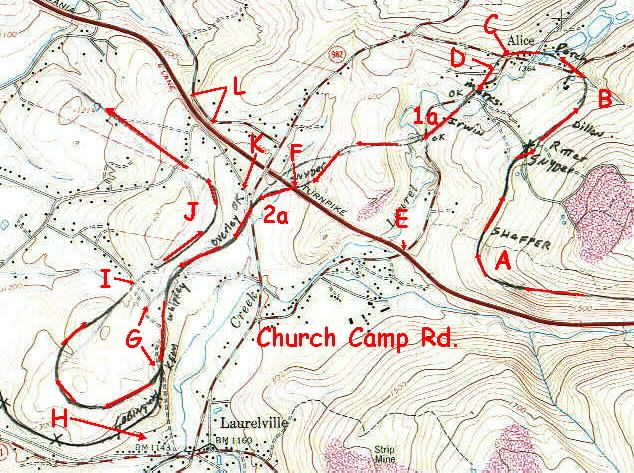
I added this map to show how I follow the proposed South Penn grade onto todays topographic maps. Remember there was not a spade of dirt turned on this mountain front. So by studying this old railroad map I was able to locate where it should have been built. Not bad for an idle period of 120 years
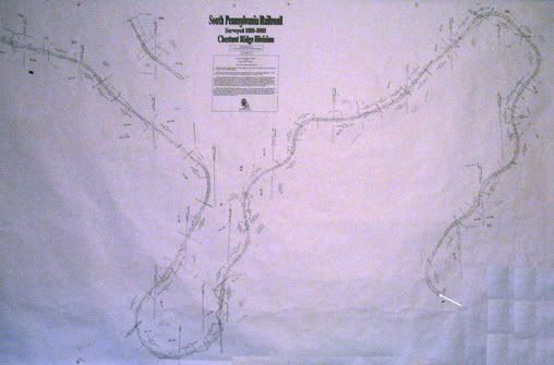
The South Penn physical work only occoured between the areas from just one mile east of the Blue Mountain tunnel to just immediatly west of the Donegal interchange. However I didn’t stop exploring the South Penn because I ran out of wrk sites. The areas where no work was done also and intreaged me even more. After acquireing the survey maps and the1884 report, I continued exploreing the clues provided and managed to piece together these plat maps to form a survey map much like they most likely did in the office. Look close if its possible to see just how many maps I had to piece together to make this map of the descent down the west slope of the Chestnut ridge between the Pennsylvania Turnpike 86.0 mile post to the 80.0 mile post. The added milage caused an extra five miles in the curves that were made. The turnpike would be just about crossig from the bottom right corner to the top left corner through this map.
http://i33.photobucket.com/albums/d64/spennrr18811885/chestnutdescent.jpg
http://i33.photobucket.com/albums/d64/spennrr18811885/pwsgradesomersetintr.jpg
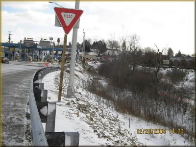
No and the proof is in this shot. Enjoy!!
Awesome stuff Russ…You’re so right, I can easily see the grade in your pic there at the entry to the toll both…{Our Hamton Inn is just out of the right side of your pic…
Well like I do, if the wife sleeps in late you can take a walk out of the room and do a little exploring and collect some PW&S photo shots. It also crossed the outside tollbooths to cross into the weed zone opposite your hotel to the south parking lot of McDonalds to the south side of Windy’s and then the parking lot of E&Park t and crossing of the creek just east of E&P to the Jenny globe site. It did make connection to the B&O line just to the feed mill located on 281.
Did I mention at all tht the now bike trail from Conellsville to Confluence was pre-surveyed by the South Penn Railroad or what was Western Maryland trough the Youghiogheny valley from Confluence to Connellsville via Ohio Pyle. I have those maps as well and a few South Penn correspondance letters.
…Must sign for a while Russ…Thanks for sharing pic’s and info of maps and photos…Enjoyed.
…I followed all of that…Will take a closer look when I’m there. Have eaten at Eat and Park many times…Home town is 10 miles north of there but we make our “home” there at the hotel when in the area…Family mostly gone.
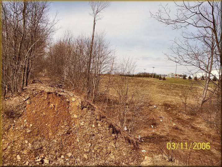
When you go on your ten mile trip north of Somerset, give a few min and stop at the back parking lot of the new Walmart loction to look see this section of South Penn grade at the very back south east corner of their parking lot. Under that grade is a stone arch culvert built there. Walmart is on the right utop the hill. Easy to get down here.
http://i33.photobucket.com/albums/d64/spennrr18811885/kennyb.jpg